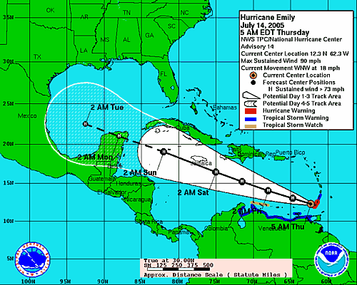
 There's a high pressure system in place over Florida, which is ensuring that Emily stays to our south.
Three cheers for high pressure! (Who knew that moving to Florida would make me into such a weather geek?)
Looks like a nice weekend for us, if we can stand the red tide, which incidentally was not cleared out by Dennis. In fact, it's worse than ever.
"One of the greatest losses resulting from the red tide that swept through much of lower Tampa Bay in recent weeks was the 16-year stockpile of Goliath grouper." [Known as Jewfish before the PC era. -Ed.]See the rest of Frank Sargeant's fishing report "Goliath Grouper Wasted By Red Tide" for the tragically smelly details.
Meanwhile, the panhandle continues its cleanup effort and tries to put life back together after two major hurricane hits in less than a year.
Gulf Coast Cleans up from Hurricane Dennis.
Some people are just done with it: Repeat Hurricanes Have Some Panhandle Residents Planning to Leave. Unless you leave Florida entirely, you won't escape the hurricanes. Ask the people in inland Polk County; they got hit three times last year.
And this one from the "meaner than hell" + "what's wrong with unions" files: Transit Workers Fired For Not Helping Evacuations Get Jobs Back. Can you feel the love? These folks wouldn't survive a day in our community. They'd be shunned for life. In fact, some of us might just take them out for a nice blanket party. Who refuses to help their neighbor when a hurricane is closing in? Assholes, that's who.
And the Florida tourism PR machine is back in business as well: Florida welcomes visitors post-hurricane Dennis.
In future news: another small area of disorganized storm activity appears to be forming, but is not expected to develop much until it reaches warmer waters:
TROPICAL WEATHER OUTLOOKWe will be, as always, monitoring the wave and hoping that our hurricane-repelling high pressure stays in place.
NWS TPC/NATIONAL HURRICANE CENTER MIAMI FL
1130 AM EDT THU JUL 14 2005
THE TROPICAL WAVE LOCATED MIDWAY BETWEEN AFRICA AND THE LESSER ANTILLES REMAINS DISORGANIZED THIS MORNING. ALTHOUGH UPPER-LEVEL WINDS ARE ONLY MARGINALLY FAVORABLE FOR TROPICAL CYCLONE DEVELOPMENT...THE WAVE WILL BE MOVING OVER WARMER WATERS OVER THE NEXT DAY OR TWO AND SOME SLOW DEVELOPMENT OF THIS SYSTEM IS POSSIBLE.
ELSEWHERE...TROPICAL STORM FORMATION IS NOT EXPECTED THROUGH FRIDAY.
FORECASTER FRANKLIN


No comments:
Post a Comment