Wednesday, August 30, 2006

Ernesto Arrives: It's Raining

Tropical Storm Ernesto
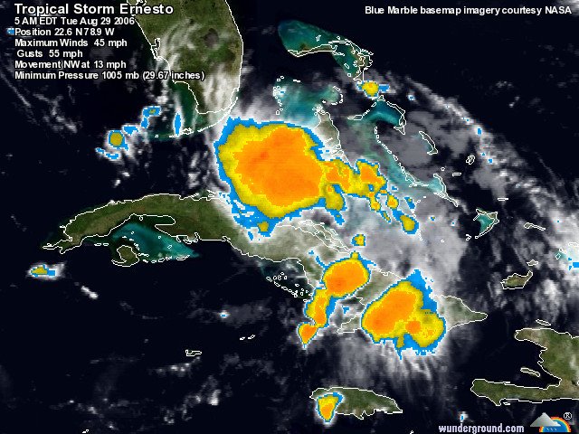
Ernesto has arrived in South Florida, but since it didn't have time to strengthen to hurricane force after leaving Cuba, it's simply a "rain event" like Alberto was.

No reports of deaths have emerged from Cuba, though the province of Guantánamo received over eight inches of rain during Ernesto's visit. Perhaps the most notable feature of this hurricane strike in Cuba was Castro's absence from the airwaves before, during and after the storm. His brother, Raúl, did not make public statements and as yet has not began surveying the damage in front of television cameras as was Fidel's custom.

From Hispaniola: The death toll in Haiti remains at two. The south end of the country suffered wind and flood damage where over 200 homes were damaged and several banana fields were completely destroyed. The Dominican Republic reported damage to over 400 homes, but no fatalities and no serious structural damage.

For our part, we're expecting rain, some wind gusts and not much else. Still, I'm happy to have been prepared for the worst even though this storm turned out to be a best-case scenario.

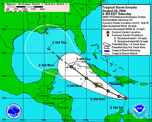
For more info on Ernesto and the latest tracking maps, visit the National Hurricane Center.

Tuesday, August 29, 2006

Ernesto On Track for Florida

Ernesto RadarAh, summer. A time for fishing, swimming, boating, beaching and watching enormous radar blobs approach the state of Florida. If you've been following the storm, you'll see the track has changed since Sunday (I couldn't write yesterday due to a small household accident that confined me to the couch) and that its prolonged journey over Cuba weakened it from a hurricane to a tropical storm. Now that it's back over water, it will restrengthen, but hopefully not much, before it makes landfall.
Ernesto Forecast Track
Ernesto is now forecast to smack into our neighbors in the Keys and run up the middle of the state before going back out to sea. A second US landfall somewhere in the neighborhood of the Carolinas is also forecast by the National Hurricane Center. Check out the satellite views of Ernesto to watch the center begin to form again.

Ernesto killed two people in Haiti before striking Cuba where it reportedly dropped some seven inches of rain. South Floridians still trying to recover from the 2005 season are being told to evacuate their FEMA trailers before the storm hits. The wisdom is undeniable: a trailer can't withstand the impact of even a strong tropical storm, but the irony and misery of the situation are also undeniable. The storm also forced NASA to cancel the space shuttle Atlantis launch.

And, if you can't take any more bad news, here's something from the humor files: FEMA claims it's ready for Ernesto. If that doesn't make you laugh, you haven't been paying attention.

Depending on the strength at landfall, we could get some tropical storm force winds here, so we'll be packing up the patio projectiles today. We have plenty of everything and we're as ready as possible...

Sunday, August 27, 2006

Good Morning, Hurricane Ernesto

Hurricane Ernesto We woke up to a new track this morning, which is not surprising this far out from landfall. Ernesto is now a hurricane and predicted to come right into our front yard. The computer models from Weather Underground show the possiblities, including a panhandle or more northerly landfall. The NHC discussion seems to indicate confidence in a west coast strike. However, it's still early and, as we learned with Hurricane Charley in 2004, anything can happen. Hurricane intensity and tracks are difficult to predict especially when they're young storms like this one.

However, given that most of the computer models agree that Ernesto will make an easterly turn once it gets into our neighborhood, we'll start boarding up the Hunker Bunker on Tuesday/Wednesday. Unless there are some drastic changes in the forecast, we'll probably have to evacuate, so all you low lying folks who count on the Bunker: let's make a plan.

Here we go, kiddies. Never a dull moment in Hurricane Land.

Saturday, August 26, 2006

Tropical Storm Ernesto to Visit the Gulf

ErnestoTropical Storm Ernesto looks as if it will make a visit to the Gulf of Mexico. The models seem to predict a North Central Gulf Coast hit. It's still too early to tell, but here's the lastest discussion from the National Hurricane Center:
AN AIR FORCE PLANE HAS BEEN INVESTIGATING ERNESTO AND FOUND THAT THE CENTRAL PRESSURE DROPPED TO 999 MB WITH A WELL-ESTABLISHED CYCLONIC CIRCULATION. HOWEVER FLIGHT LEVEL WINDS HAVE NOT INCREASED MUCH SINCE THE PREVIOUS FLIGHT. IT APPEARS THAT THE CENTER IS LOCATED ON THE WESTERN PORTION OF THE LARGE DEEP CONVECTIVE MASS DUE TO THE CURRENT SOUTHWESTERLY WIND SHEAR. ALTHOUGH DVORAK INTENSITY ESTIMATES SUPPORT 45 KNOTS...THE INITIAL INTENSITY IS KEPT AT 40 KNOTS BASED ON AVAILABLE REPORTS FROM THE AIRCRAFT. ERNESTO HAS BEEN A FIGHTER AND HAS BEEN ABLE TO SURVIVE THE STRONG SHEAR SO FAR. UNANIMOUSLY...ALL GLOBAL MODELS DEVELOP AN UPPER-LEVEL RIDGE OVER ERNESTO...A PATTERN WHICH IS CONDUCIVE FOR STRENGTHENING. THIS UPPER-LEVEL PATTERN COMBINED WITH THE VERY WARM WATERS AHEAD OF THE CYCLONE COULD LEAD TO SIGNIFICANT STRENGTHENING OVER THE NEXT FEW DAYS. THIS COULD RESULT IN ERNESTO BECOMING A POWERFUL HURRICANE IN THE GULF OF MEXICO. THE INTENSITY FORECAST IS LOWER THAN THE GFDL AND VERY SIMILAR TO SHIPS AND FSU SUPERENSEMBLE. OF COURSE...THE INTENSITY FORECAST IS HIGHLY UNCERTAIN AND STRENGTHENING MAY NOT OCCUR AT ALL IF THE SHEAR DOES NOT DECREASE.

IN SUMMARY...ERNESTO COULD BECOME A POTENTIALLY DANGEROUS HURRICANE AS IT MOVES ACROSS THE NORTHWESTERN CARIBBEAN SEA AND THE GULF OF MEXICO. INTERESTS IN THESE AREAS SHOULD CLOSELY MONITOR THE PROGRESS OF THIS SYSTEM.
We'll be monitoring. Believe me.

Wednesday, August 23, 2006

Tropical Storm DebbyTropical Storm Debby appears to shaping up as a good fish storm and nothing more. The National Hurricane Center discussion indicates that Debby might yet strengthen into a hurricane, but the models predict that she will avoid land and make a hard right out to sea.

More as the activity off the Cape heats up. It's that time of year...

Friday, August 04, 2006

Tropical Depression Chris

Chris seems to be falling apart. The 8:00 advisory from the NHC downgraded Chris from a Tropical Storm to a Tropical Depression. As it continues on its way west, it continues to sink south, away from Florida.

This makes for a slow day (thankfully) in Hurricane Land and means my trip to Dallas isn't likely to be interrupted by Chris. Summer thunderstorms are always a wildcard, but hopefully I'll get out and back without being delayed at the second worst airport in the country: DFW.

Stay tuned to Hurricane Land...We're just getting warmed up.

Wednesday, August 02, 2006

Chris Gets Its Act Together

Tropical Storm Chris
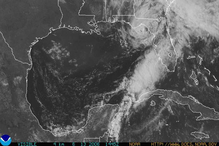
http://www.nhc.noaa.gov/satellite.shtml

Tropical Storm Chris is getting its act together. While I don't think this will affect the west gulf coast, any storm in the area bears watching. Besides, it's a good reminder to check your supplies. We replaced the batteries in our weather radio today. ..something we should have done weeks ago when Alberto breezed through.
The computer models have yet to converge and the discussion over at the National Hurricane Center goes like this:
WTNT43 KNHC 021447TCDAT3
TROPICAL STORM CHRIS DISCUSSION NUMBER 8
NWS TPC/NATIONAL HURRICANE CENTER MIAMI FL AL032006
1100 AM EDT WED AUG 02 2006

Data from the San Juan WSR-88D Doppler radar and high-resolution visible satellite imagery suggest that Chris is gradually becoming better organized as it continues toward the west-northwest near 9 KT. Initial intensity is set at 55 kt in accordance with the last recon-measured flight-level winds of 67 kt and DVORAK T-numbers of 3.5 from both TAFB and SAB. Cirrus motions indicate that Chris continues to be experiencing some northerly shear. On the predicted track...and based on the 200 MB wind forecast from the GFS...Chris will be in a COL region between two upper-level cyclones during the next few days. This is a reasonably favorable upper-level environment...so a gradual increase in strength is forecast. The NHC wind speed forecast is similar to the latest ships guidance and a little above the FSU Superensemble prediction. As always...it should be recalled that tropical cyclone intensity forecasts at 3-5 days have little skill.

Latest center fixes suggest little change in the initial heading or speed. Global models indicate that the mid/upper-level low near the Central Bahamas will move westward and slowly weaken over the next few days...while a rather strong mid-tropospheric ridge builds to the north of Chris. This kind of flow pattern would steer the tropical cyclone on a general west-northwestward track. However an even stronger ridge would likely drive Chris westward. Indeed...this is the scenario offered by the GFDL model which even turns the system west-southwestward for a while. Whereas the GFDL is a highly credible model...the most prudent course at this time is to use the consensus of all of the dynamical models. This is also very similar to the previous NHC track. [Emphasis mine]
Even though we're in the five-day cone there's no need to worry about Chris at the moment, but it's always best to be prepared. Personally, I'm not all that fond of fighting my friends and neighbors for basic supplies while a storm howls out in the Gulf. That's why I've been looking at over a dozen gallons of purified water sitting here on the floor of my home office since before June first.

If you live in Florida, think of Chris as your second wake-up call. If you hit the snooze button after Alberto, it might be wise to put your feet on the floor this time and start getting ready to survive up to a month without power or water.

The height of hurricane season is coming. And FEMA isn't.

Tuesday, June 13, 2006

Alberto the Rainmaker

Alberto is still passing through Florida, dropping a ton of rain and causing some storm surge flooding. As Alberto nears landfall, it has yet failed to reach hurricane strength.

It's just about onshore near Cedar Key now and is predicted to pass through North Carolina as it falls apart. I'm in Texas, but reports from home say Alberto caused some minor flooding, a lot of rain and a few miserable days that remind my husband of living in Oregon.

You can see from NOAA's visible images that it's not much of a storm, but hold on to your hats, folks...today is only day 13 of the season. If your hurricane preparations are behind schedule, Alberto's visit to Hurricane Land should remind you to get ready, get set and if you have to, GO!


Photo Courtesy NOAA

Sunday, June 11, 2006

And So It Begins...

Tropical Storm Alberto is the first named storm of the season. I'm off to Dallas tomorrow, provided planes are taking off from Tampa, but I'll try to monitor the storm from there. It should be quite the rainmaker, but yes, we're prepapring for the worst.

Read the latest advisory from NOAA.

See the 3-day forecast track

Welcome to Hurricane Season 2006!