000Sigh.
WONT41 KNHC 301605
DSAAT
SPECIAL TROPICAL DISTURBANCE STATEMENT
NWS TPC/NATIONAL HURRICANE CENTER MIAMI FL
1100 AM EST FRI DEC 30 2005
SATELLITE IMAGERY INDICATES THAT AN AREA OF LOW PRESSURE IN THE EASTERN ATLANTIC HAS DEVELOPED INTO A TROPICAL STORM ABOUT 1000 MILES SOUTH-SOUTHWEST OF THE AZORES. A SPECIAL ADVISORY ON TROPICAL STORM ZETA IS IN PREPARATION AND WILL BE ISSUED IN AN HOUR OR SO.
FORECASTER FRANKLIN
Friday, December 30, 2005
Tropical Storm Zeta? Say it ain't so!
But NOAA says it is so.
Monday, October 24, 2005
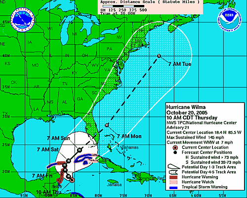
Wilma Arrives in Florida
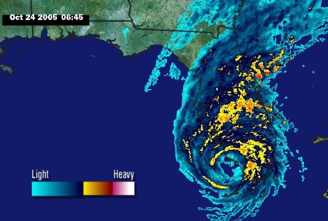 It's windy. Wilma came ashore as a category three hurricane about an hour ago at Marco Island, just south of Naples. (Wendy: I'm glad you evacuated!)
 We're seeing tropical storm force winds with gusts brushing hurricane force in certain areas. We've been under tornado watch since last night. It's blowing pretty good out there, but we're spared the worst of it. Of course, schools are closed and no one is going to work today. We're supposed to get a cold front right after the storm, so the weather will go from tropical to winter in the space of a few hours. Right now it's humid and I can smell the warm rain through walls.
It's 7am and we're safe and dry. More later.
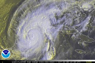
Saturday, October 22, 2005
Good Morning Wilma
Wilma, finished with Cozumel, slammed into the Yucatán peninsula. Because the storm is lingering, it could drop as much as 20 inches of rain on Cancún. Story...
 The guidance models appear to be coming into agreement, making the NHC more certain of its forecast. However, the local news stations aren't in agreement as to whether Tampa is in the cone or not. Bay News 9 shows the cone just covering the edge of Manatee county, leaving Tampa out, but covering our area. The folks at Fox 13 News are broadcasting a broader cone, which agrees with the NHC's cone. So, while I cannot believe I am saying this: I believe Fox News.
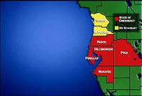 Manatee County has declared as state of emergency, but we're not under any directions from emergency management officials. The NHC seems fairly certain of its forecast, but it also predicts a very large windfield as the hurricane gets pulled apart as it crosses the Gulf of Mexico.
Where does this leave us? Unknown. Right where we've been since Wilma was named. Watching and waiting. Any change in the steering conditions and the forecast could change in a heartbeat.
Stay tuned. We'll be spending most of the day preparing for the storm to hit us even though everyone says it's not going to. I know, I know. It's madness. Welcome to Paradise.
 The guidance models appear to be coming into agreement, making the NHC more certain of its forecast. However, the local news stations aren't in agreement as to whether Tampa is in the cone or not. Bay News 9 shows the cone just covering the edge of Manatee county, leaving Tampa out, but covering our area. The folks at Fox 13 News are broadcasting a broader cone, which agrees with the NHC's cone. So, while I cannot believe I am saying this: I believe Fox News.
 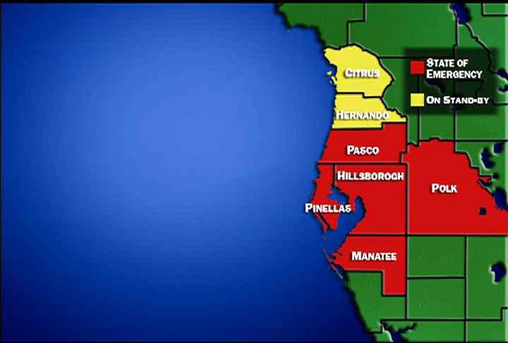 Manatee County has declared as state of emergency, but we're not under any directions from emergency management officials. The NHC seems fairly certain of its forecast, but it also predicts a very large windfield as the hurricane gets pulled apart as it crosses the Gulf of Mexico.
Where does this leave us? Unknown. Right where we've been since Wilma was named. Watching and waiting. Any change in the steering conditions and the forecast could change in a heartbeat.
Stay tuned. We'll be spending most of the day preparing for the storm to hit us even though everyone says it's not going to. I know, I know. It's madness. Welcome to Paradise.
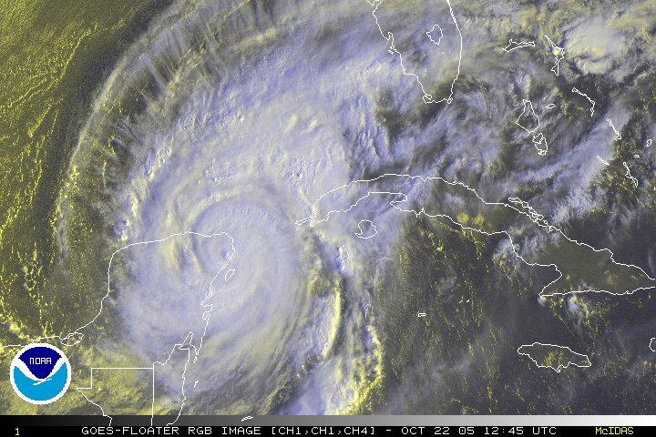
Friday, October 21, 2005
Wilma Slams Cozumel

Wilma crashed into the shores of Cozumel this morning and is now headed for the Yucatán peninsula and Cancún. Story...
I don't know where our friends are at this point. Our attempts to reach them have failed. When we saw images of the shelters set up in Cancún, all we saw were tourists - no brown faces in the crowd. I hope their government is taking better care of them than ours did the poor citizens of New Orleans. Not surprisingly, Novedades, México's online newspaper seems to be offline. I guess we wait.
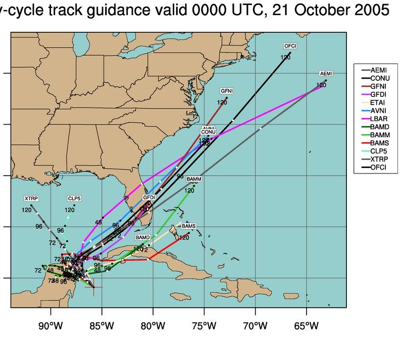 Meanwhile, the uncertainty grows as to where and when Wilma will strike Florida's Gulf Coast. Workers are outside my window boarding up the top floor of our building. We are all taking precautions to safeguard our data in the event we take a direct hit. The map at left from Weather Underground's Steve Gregory shows that most of the models are still converging on South Florida while one stubbornly tracks north, predicting a Tampa Bay landfall. The NHC discussion indicates that the wide spread in the models so "both the location and the timing of the impacts on Florida remain very uncertain."
For this reason, I believe we will hang our hurricane shutters tomorrow - at least if I have anything to say about it, which I certainly do. Haha. The storm is just too unpredictable and I'd rather be shuttered in the calm than unprotected in the storm. So, the hunker bunker won't be open this weekend, but it will be open on Monday, if necessary.
To friends and family around the country and the world: try not to worry. We are smart, strong and prepared. We will do whatever it takes to weather the storm.
Thursday, October 20, 2005
Wicked Wilma
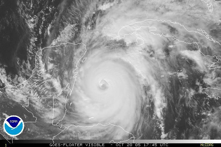 Wilma is shaping up to be one of the nastiest storms on record. It will probably restrengthen to a category 5 before slamming into the Yucatán peninsula sometime tonight or tomorrow morning. I'm very worried about our friends in that area, but so far my attempts to contact them have failed. Hopefully, that means they are on their way away from the sea.
 We are still taking a wait-and-see attitude toward hanging the shutters because Wicked Wilma has slowed some and we can't get a good read on whether it is worth the effort or not. We do expect to experience tropical storm force winds when Wilma crosses the state due to upper level conditions that will work to pull part of the storm to the north as it crosses Florida.
The models are now shifting even farther south, but Tampa Bay is still in the cone. Remember: don't focus on the line...you have to prepare if you are anywhere inside the cone. Preparation will make all the difference to your comfort and perhaps your survival in the event of a hit.
Remember:
Run from the water.
Hide from the wind.
Please stay safe everyone.
Wednesday, October 19, 2005
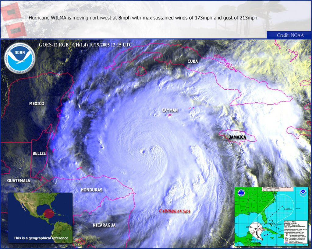
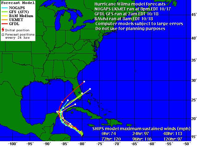
Wilma: Cat 5
Wilma became a category five overnight, but it is not expected to sustain its strength. It is expected to hit Florida, the 64-dollar question being: Where?
The "spaghetti models" are in pretty good agreement for a southerly landfall, but those of us who remember Charley remain skeptical, to say the least. You can see that only one of the models takes Wilma through Tampa bay, but that's enough to keep my attention. Jim and I will be watching carefully and preparing to board up and/or run, if necessary. Check back here for updates as I am able to post them.
The Hunker Bunker is tentatively open for business this weekend to our islander friends and those in low-lying Cortez. We have food, water, flashlights, board games and candles. Bring beer.
Tuesday, October 18, 2005
New Models - GFDL Shifts to the South
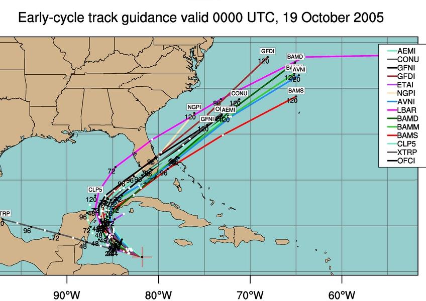
 GFDL, GFS and UKMET models have been updated. You can see that the GFDL, which had tracked Wilma up to Tampa Bay, has shifted south. The NOGAPS remains on a northerly track, but it hasn't run since 10pm yesterday. The NHC insists the models are in good agreement, so we'll have to wait to see what happens as the evening progresses and NOGAPS runs again.
 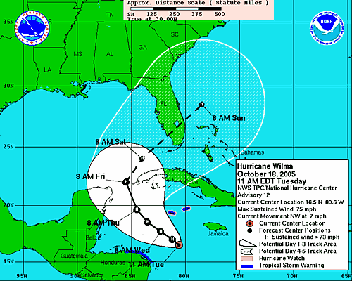 I strongly encourage everyone to keep in mind that we cannot focus on the tracks for either damage or exact landfall. We have to look at the cone and where we will be upon landfall. If you are on the Gulf Coast, you should be making preparations for both evacuating and hunkering down right now. Unless of course you enjoy getting in a fist fight with your neighbor over the last gallon of water at Winn-Dixie.
 As Wilma approaches, remember the two rules:
1. RUN from the waterI will, of course, be watching carefully and keeping the site updated.
2.HIDE from the wind.
A note from Phil
Phil, friend of the list from the Florida Panhandle has this to contribute:
Hello....ltns.Thanks, Phil. Looks like you'll be keeping an eye on the peninsula instead of the peninsula keeping an eye on y'all for this one. As always, I'll be watching...and yes, this time without my cigarettes! Hang on...we're goin' for a ride and I ain't talkin' hay ride.
Wilma also ties the record for the 21st significant Storm ... (back when we had 21 tropical storms or greater, was in the 1920's, when we werent yet naming them)..... but it ties that record, and that was the most active hurricane season on record...We are now all *OUT* of hurricane names, and the store doesn't get restocked until 2006. The Greek list is available, at a discounted clearance price.
God Bless,
Phil/Pensacola
Wilma Makes 12
Wilma makes 12 hurricanes for 2005, tying the record set in 1969 for most hurricanes in a year. It's shaping up to be a nasty storm and I'm not liking the computer models much. Win lose or draw, Wilma will hit the Gulf Coast of Florida, giving the insurance companies more reason to stick it to us again, even if our neighborhood doesn't take a direct hit.
You can see from the models above that the NHC ia pretty confident of a Florida hit. It's just too soon to tell when, where and how sharply Wilma will turn before making landfall. The discussion points out that the intensity is tough to forecast, but the waters in the Gulf are about eight degrees lower than a month ago. To my way of thinking, that's good news for all of us.
We're just wondering if we're going to be spending Friday night and all day Saturday putting up our shutters. It's sure starting to look like it. I guess we'd better prepare the hunker bunker.
And the fun never ends in Hurricane Land...
Sunday, October 16, 2005
Shutters? In October?
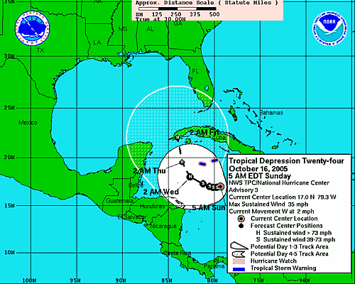
Here comes Wilma. Unbelievable. The NHC discussion this morning predicts strengthening to 88kt within 96 hours, which means we now have another major hurricane headed for the Gulf of Mexico. Simply unbelievable. When TD #24 is named, and I fully believe it will be, it will be called "Wilma." That's the last name on the list for 2005 boys and girls. After that, we have to go to letters in the greek alphabet. Is it just me or is it disconcerting to think of hurricanes called "Alpha" and "Omega"?
Hold tight kiddies. Wilma's here to remind you that hurricane season ain't over until it's over.
Monday, September 19, 2005
Phillipe & Rita - And Me Without My Cigarettes
Maybe Hurricane Season Isn't The Best Time to Quit Smoking?1
I've been away - again - because eleven days ago, my husband and I...drum roll... stopped smoking! I couldn't watch the tropics or any kind of news, really. I couldn't do much of anything besides concentrate on not-not-not lighting one of those filthy, nasty, stinking tubes of pure death. I won't go into the whole sordid thing here, but eleven days into freedom from that utter slavery to nicotine, I just have this to say: Freaking YIPPPPEEEEEE for us!2
 Meanwhile, the dastardly hurricane season trucks along oddly uncaring that I've been jonesing for tobacco. I know, bizarre, eh?
The Florida Keys are preparing to be hit by Rita, which looks like it will become a hurricane pretty much any minute now, if it hasn't already. Mandatory evacuations are underway and I can't help but wonder who's looking out for the poor in the Keys. Yes, there are poor people in the Keys. Who do you think cooks and brings your food in the restaurants, makes up your beds in the hotels and picks up your garbage when you leave? And no, they aren't paid a wage that allows them to live in one of those quaint stilt houses over the water. They're barely paid a wage that allows them to live in their cars.
But I digress.
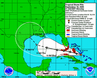
The five days forecast indicates Rita will probably make landfall in Texas (AKA El Territorio Ocupado) after it blows over the Keys. This is not good news for Texas as the Gulf is a perfect hurricane-fueling 90 degrees right now and Rita has lots of time to gather strength as it crosses the Gulf.
On its way, Rita will likely do even more damage to already storm ravaged oil interests in the Gulf and oil prices are already on the rise. Note to idiot eco-terrorist oil companies: Maybe Hurricane Land isn't the best place to locate your drilling operations. Nevermind the fragile ecosystem; everyone knows you don't give a crap about the oceans or skies, but you could have at least some regard for your own bottom line. Oh, that's right. You don't have to worry about that. You know Americans will pay $6 or even $10 per gallon to drive their Hummers. Ha. We'll see. I do believe we will get to test the theory.
But again, I digress.
Philippe (pronounced Phil-eep, I think) appears to want to become a harmless fish storm, though it still bears watching. The NHC says that while there is a broad area of low pressure between the Cape Verde Islands and the Lesser Antilles, conditions do not look favorable for development. I've come to adore that phrase: "conditions do not look favorable for development." Music. Pure music. Of course, I'll be keeping an eye on things.
Good to be back, folks.
====FootNotes====
1. Answer: Any time is a good time to quit smoking. Contrary to smokers' beliefs, smoking has little-to-no effect on hurricanes. Besides, where you gonna get your nicotine fix when the whole city is underwater?
2. Our friend over at Captain's Blog quit, too. It's an epidemic!
I've been away - again - because eleven days ago, my husband and I...drum roll... stopped smoking! I couldn't watch the tropics or any kind of news, really. I couldn't do much of anything besides concentrate on not-not-not lighting one of those filthy, nasty, stinking tubes of pure death. I won't go into the whole sordid thing here, but eleven days into freedom from that utter slavery to nicotine, I just have this to say: Freaking YIPPPPEEEEEE for us!2
 Meanwhile, the dastardly hurricane season trucks along oddly uncaring that I've been jonesing for tobacco. I know, bizarre, eh?
The Florida Keys are preparing to be hit by Rita, which looks like it will become a hurricane pretty much any minute now, if it hasn't already. Mandatory evacuations are underway and I can't help but wonder who's looking out for the poor in the Keys. Yes, there are poor people in the Keys. Who do you think cooks and brings your food in the restaurants, makes up your beds in the hotels and picks up your garbage when you leave? And no, they aren't paid a wage that allows them to live in one of those quaint stilt houses over the water. They're barely paid a wage that allows them to live in their cars.
But I digress.
The five days forecast indicates Rita will probably make landfall in Texas (AKA El Territorio Ocupado) after it blows over the Keys. This is not good news for Texas as the Gulf is a perfect hurricane-fueling 90 degrees right now and Rita has lots of time to gather strength as it crosses the Gulf.
On its way, Rita will likely do even more damage to already storm ravaged oil interests in the Gulf and oil prices are already on the rise. Note to idiot eco-terrorist oil companies: Maybe Hurricane Land isn't the best place to locate your drilling operations. Nevermind the fragile ecosystem; everyone knows you don't give a crap about the oceans or skies, but you could have at least some regard for your own bottom line. Oh, that's right. You don't have to worry about that. You know Americans will pay $6 or even $10 per gallon to drive their Hummers. Ha. We'll see. I do believe we will get to test the theory.
But again, I digress.
Philippe (pronounced Phil-eep, I think) appears to want to become a harmless fish storm, though it still bears watching. The NHC says that while there is a broad area of low pressure between the Cape Verde Islands and the Lesser Antilles, conditions do not look favorable for development. I've come to adore that phrase: "conditions do not look favorable for development." Music. Pure music. Of course, I'll be keeping an eye on things.
Good to be back, folks.
====FootNotes====
1. Answer: Any time is a good time to quit smoking. Contrary to smokers' beliefs, smoking has little-to-no effect on hurricanes. Besides, where you gonna get your nicotine fix when the whole city is underwater?
2. Our friend over at Captain's Blog quit, too. It's an epidemic!
Wednesday, September 07, 2005
And from the "More Incompetence From FEMA" Files
Apparently, FEMA is only interested in giving relief to Micro$oft and PC users.
Sorry, Mac and/or Firefox users...no soup for YOU!!!
Your tax dollars at work, kiddies.
FEMA's website can only be accessed by people using a PC which has Internet Explorer 6. Some of it is viewable using Firefox but anyone trying to apply for Disaster Assistance needs to use IE 6.0 or higher.Read More...
Sorry, Mac and/or Firefox users...no soup for YOU!!!
Your tax dollars at work, kiddies.
And now for Ophelia...
Tropical Storm Ophelia is spinning off the east coast of Florida. This one looks like it might curve out and miss the Sunshine State, according to the latest from the NHC. I was looking forward to the rain, but after last year, it's tough to wish for a storm to hit.
And this from from Phil in repsonse to last night's post:all the rich. While it always seems FEMA et al. are too slow to respond, this response was slower than most. And if the authorities had secured the city immediately as is their...um...JOB...the junkies wouldn't have been firing on the rescue 'copters.
That said, I completely agree with this comment: "No more sending people that are supposed to protect U.S. Citizens in the U.S., to foreign fucking countries." Preach it brothah! Amen! Bring 'em home.
The response to this disaster does not give me confidence that so-called "homeland security" is prepared for a major terrorist attack. When we couldn't even handle a hurricane we knew was coming? Homeland Security is worse than a joke - it's a waste of time and money.
Care to discuss folks? Please go to the site and use the comments area as I do not allow replies back to the list.
And this from from Phil in repsonse to last night's post:
Most of New Orleans is black... The color of their skin had nothing to do with the speed of relief agencies. On the other hand, the fucking idiots that decided to shoot at rescue helicopters attempting to land at hospitals...... uhm......DID.... I *still* think at the MINIMUM Louisiana's own National Guard should have been there immediately. No more sending people that are supposed to protect U.S. Citizens in the U.S., to foreign fucking countries.Okay, Phil...I'll give you that the major portion of New Orleans' population is black, so my color comment may or may not have been fair. But I still believe that the response would have been faster and greater for the rich. That's simply the way America works. Liberty and Justice for
God Bless,
Phil
That said, I completely agree with this comment: "No more sending people that are supposed to protect U.S. Citizens in the U.S., to foreign fucking countries." Preach it brothah! Amen! Bring 'em home.
The response to this disaster does not give me confidence that so-called "homeland security" is prepared for a major terrorist attack. When we couldn't even handle a hurricane we knew was coming? Homeland Security is worse than a joke - it's a waste of time and money.
Care to discuss folks? Please go to the site and use the comments area as I do not allow replies back to the list.
Tuesday, September 06, 2005
TD #16, Nate and Maria
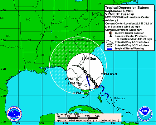 TD #16 should make landfall on Florida's east coast before it becomes a named storm. Hurricane Maria and Tropical Storm Nate have also arrived in the Atlantic; both are projected to become "fish storms."
 If you're wondering why I haven't posted much lately, it's because I've been watching the horror that is Katrina's aftermath unfold. Since this is a Florida-centric blog, and since I've pretty much had my say on Katrina, I've been quiet.
But now it's getting active out there again, so I'll be back when there is more to report. In the meantime, make sure you are prepared for a category 5 storm. Take a lesson from the misery in Louisiana and Mississippi: you need more than three days worth of supplies (especially if you happen to be poor and/or dark-skinned...but I digress.)
Please stay safe and remember the Two Rules of hurricane survival:
RUN from the water
HIDE from the wind
Friday, September 02, 2005
New Orleans Burning
I have been quiet for the last few days in deference to the unfolding disaster along the Gulf coast. I have also been hopping mad at the government, its agencies and the pundits and talking heads on television who intellectualize and rationalize to cover their asses. All of them fiddling while New Orleans burns and Biloxi and Gulfport wonder if anyone even knows they're alive.
But you can help.
Are you retired? Do you have the means to make it to one of the relief areas such as Houston or San Antonio? Perhaps you could volunteer to work one of the refugee facilities.
Are you a medical professional with time on your hands? Perhaps you can volunteer for the Red Cross's relief effort.
Can you answer phones? Tear open an envelope? The Red Cross needs volunteers for all kinds of unglamorous work that nonetheless serves the cause. Tell them you'll empty trash cans if that is what they need...every job is vital now.
Do you have little time but some extra cash? Perhaps you can make a donation to the Red Cross. They accept everything from stocks to frequent flyer miles.
Do you live in the southeast? Do you have an extra room? Can you shelter a refugee family for a few months? MoveOn's Hurricane Housing Effort
or, if you're not fond of MoveOn: KatrinaHome.com
And last, but not least: Pray. Pray in whatever way is appropriate to your belief system because this is the biggest, baddest thing that has ever happened to this country, including the horrific attacks on the trade centers and the Pentagon.
And now for the soapbox portion of the post:
There is little doubt that as New Orleans, currently little more than a drowning pool for the poor and helpless, descends into anarchy that this is one of the darkest days in American history. The federal government has been torturously slow in responding to cries for help.
And where is the National Guard whose sole reason for being is to protect Americans in America? They are, at your expense, watching in horror from Iraq. Sent to die in a senseless, unwinnable war authorized by Republicans and Democrats alike. Want to hate someone for this atrocity unfolding before us? Hate both sides, folks. Both are equally to blame. I'm not pointing fingers at only "red" or only "blue" politicians...they all suck as far as this crisis goes. The lack of action from all corners of the federal government is as staggering as the disaster.
And I don't want to hear any excuses about the magnitude of the disaster and how they need time to gather the resources to deal with it. Bullshit. They all knew this was coming. The feds, the states, everyone knew this was not an "if" situation, but a "when." So no amount of bullshit, no amount of whining, no amount of rationalization and justification from the dumb asses on Capitol Hill can erase their culpability in this tragedy. They knew. They did not act. If I performed my job like that, I would be so fired. Think about that in November 2006.
In the meantime, maybe we should stop listening to their lame excuses and wondering when they are going to send help. It's time the citizens, who are truly what makes this country great, take matters into our own hands and help the poor and needy of the once great city of New Orleans and the rest of the forgotten and forsaken.
Please...open your heart, your home or your pocketbook. While the most powerful government on Earth whines about how they can't get it together enough to do their freaking jobs, little ol' you can do something.
Monday, August 29, 2005
A Picture is worth...
Courtesy NOAA
 Katrina Makes Its Way Inland
Courtesy NOAA
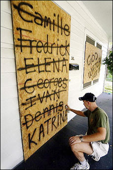 'Nuff Said
AP Photo
 Perspective: This is 100 miles from the eye of the storm
 AP Photo
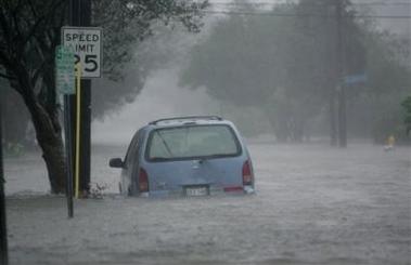
 New Orleans Takes a Hit
 AP Photo
 Blown Out Windows in Downtown New Orleans
 Reuters Newswire
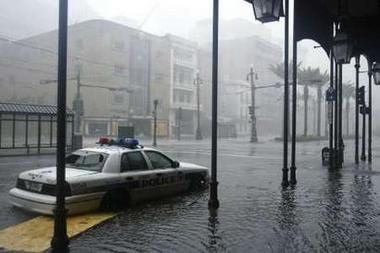 Police Cruiser Stranded on Canal Street
Note the Plywood Floating Under the Back End
AP Photo
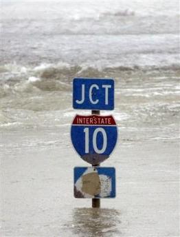 A Bit Tough To Find the Interstate
Reuters Newswire
 Downtown New Orleans
 AP Photo
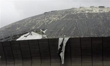 Katrina Peels Roof Off of Super Dome in New Orleans
 AP Photo
 Taking Refuge in a Doorway on Bourbon Street
I can't help wondering what became of Blair Quintana and Patrick Lamparo...
Are they homeless? Why didn't they go to the Super Dome?
What became of them when Katrina passed?
AP Photo/Dave Martin
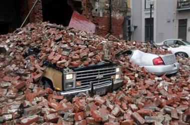
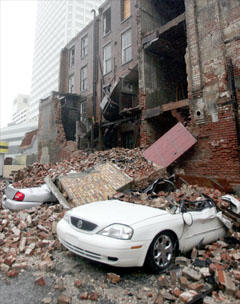
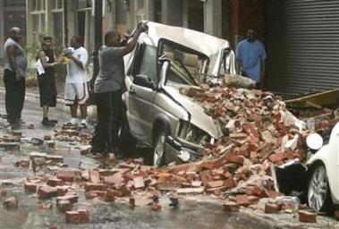 Collapsed Building in New Orleans
 AP Photo
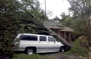
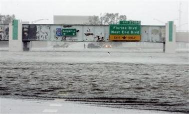 Mound Underpass, I-10, New Orleans
 AP Photo
 Uptown New Orleans
 AP Photo
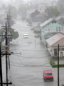
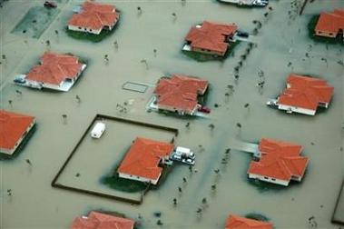
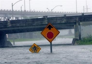 New Orleans Under Water
 AP Photo
 Nothing Will Be Easy in "N'awlins" For a While
AP Photo
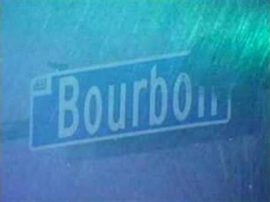 Beloved Bourbon Street in the Rain
AP Photo
 Lake Pontchartrain Floods LaCombe, LA
 AP Photo
 Gulfport, Mississippi
AP Photo
 Gulfport Mississippi
 AP Photo
From the Perspective Files:
Here are some photos from South Miami Dade County, Florida from last week when Killer Katrina was "only" a category one 'cane.
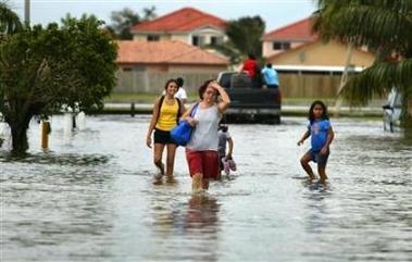 Flooding In Miami-Dade
AP Photo
 Katrina's Wrath at Category One
 AP Photo
Killer Katrina: I'm At A Loss for Words
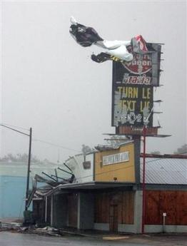
 As the National Weather Service reports parts of metropolitan New Orleans have suffered total structural failure, a section of levee has given way, flooding the Ninth Ward neighborhood, the roof of the Super Dome appears to be peeling away, at least one hundred people are trapped on their roofs by rising flood waters , the storm blew out windows in high rise hotels (including the Hyatt where I stayed during my last visit), and at least ten people have died due to Killer Katrina: seven in Florida and three in Louisiana, I find myself at a loss for words.
 Meanwhile TD #13 spins northeast of the Lesser Antilles another wave forms off of Cape Verde.
 I don't have anything else to say.
Sunday, August 28, 2005
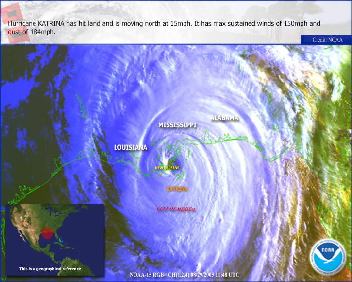
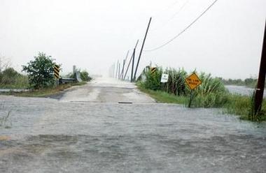
The Perfect Hurricane
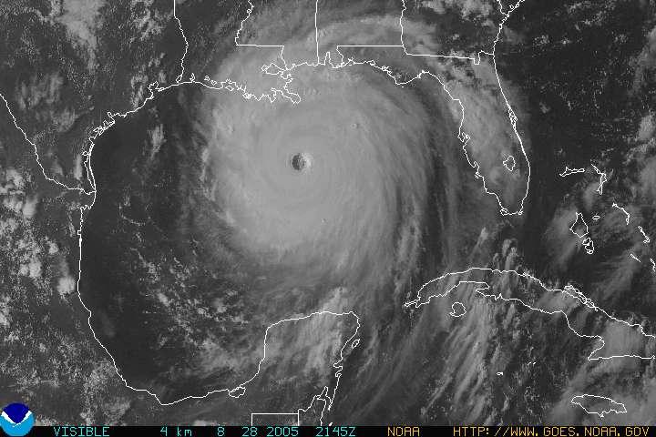 Katrina's windfield is now 100 miles wide. If Katrina maintains its strength, which the NHC lastest discussion says is likely as there is no upper level shear or other factors to mitigate the power it is currently drawing out of warm Gulf waters, it will come ashore as a category four or five hurricane.
When you wake up in the morning, New Orleans might be gone. I'm not kidding. To understand the force of even a category one hurricane, Google Katrina + Fort Lauderdale. About a half million people are still without power on the east coast of Florida and there is widespread flooding throughout the metro areas near Katrina's first landfall. Seven people have already died.
This could well be the worst natural disaster in the history of the United States. Katrina is simply the perfect hurricane. If you look at the picture above, you can see the deep convection in the center, the nearly perfectly formed eye...it's a
terror.
While we are relieved to be spared this time, we are acutely aware that others will suffer in our place. Whatever you do to express empathy for your fellow beings...pray or meditate or send energy, it doesn't matter...just please do it now for the people living in the path of Katrina. Only one thing is sure: wherever this storm comes ashore, it will leave widespread destruction and human misery in its wake.
Our hearts and minds are with our brothers and sisters on the northern Gulf coast.
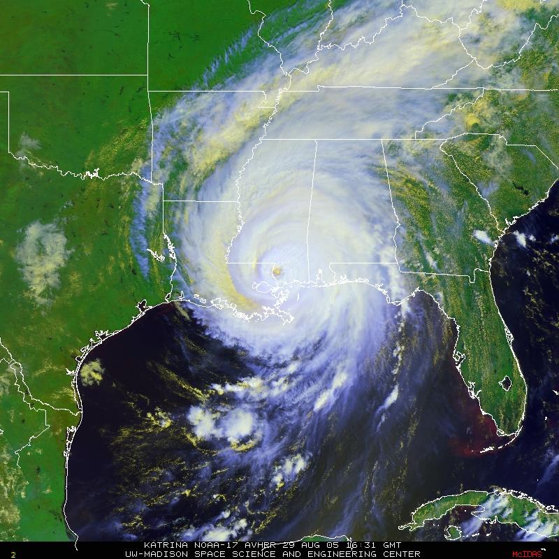
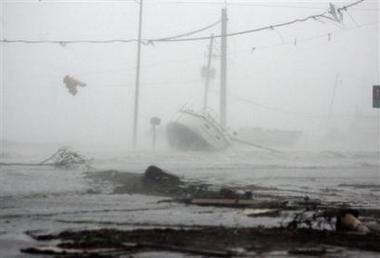
Big Easy Braces for Monster Katrina
Hurricane Katrina is now a category five storm. It's impressive to say the least. The eyewall is sharply defined and nearly symmetrical. Winds are currently at 160 mph as Katrina takes aim at one of my favorite cities in the United States: New Orleans. 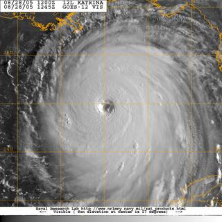 If Katrina's eye makes a direct hit or passes just west of the city, words like "catastrophic" and "devastating" will not begin to describe the damage. New Orleans lies below sea level and the city relies on a delicately balanced system of levees and pumps to keep water from engulfing the city. With a category five, the storm will send a twenty foot (or more) wall of water rushing into city. The levees designed to keep the sea out, will hold the storm surge in. Ironic, isn't it? Even if the power stays on, which is highly unlikely, the city's pump system cannot handle the volume of water that will accompany a category five or even a category four storm. See Eric Berger's Sci Guy Blog for an in-depth discussion of the potential Waterloo New Orleans is now preparing to meet.
Residents are streaming out of the city now. Many elderly residents have lived in New Orleans all their lives and have never owned or even drove a car. (You don't need a car in New Orleans. It's beautifully designed for walking and public transport.) Officials say they are trying to get to these people, but...well...figure it out...they simply can't get to everyone.
Wherever Katrina comes ashore, it's not going to be pretty. This is one hell of a huge storm. It scares me to look at it - even knowing it's not going to come ashore here. Let's just hope and pray that Katrina decides to pass a bit east of the Big Easy. Our thoughts are with everyone - on land and sea - in Katrina's path.
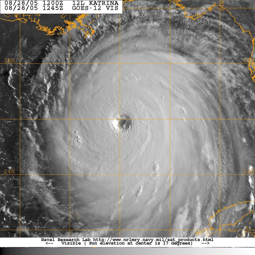 If Katrina's eye makes a direct hit or passes just west of the city, words like "catastrophic" and "devastating" will not begin to describe the damage. New Orleans lies below sea level and the city relies on a delicately balanced system of levees and pumps to keep water from engulfing the city. With a category five, the storm will send a twenty foot (or more) wall of water rushing into city. The levees designed to keep the sea out, will hold the storm surge in. Ironic, isn't it? Even if the power stays on, which is highly unlikely, the city's pump system cannot handle the volume of water that will accompany a category five or even a category four storm. See Eric Berger's Sci Guy Blog for an in-depth discussion of the potential Waterloo New Orleans is now preparing to meet.
Residents are streaming out of the city now. Many elderly residents have lived in New Orleans all their lives and have never owned or even drove a car. (You don't need a car in New Orleans. It's beautifully designed for walking and public transport.) Officials say they are trying to get to these people, but...well...figure it out...they simply can't get to everyone.
Wherever Katrina comes ashore, it's not going to be pretty. This is one hell of a huge storm. It scares me to look at it - even knowing it's not going to come ashore here. Let's just hope and pray that Katrina decides to pass a bit east of the Big Easy. Our thoughts are with everyone - on land and sea - in Katrina's path.
Friday, August 26, 2005
Update: Katrina Will Strengthen to Category 4 Before Second Landfall
This just in from the NHC:
KATRINA IS EXPECTED TO BE MOVING OVER THE GULF LOOP CURRENT AFTER 36 HOURS...WHICH WHEN COMBINED WITH DECREASING VERTICAL SHEAR...SHOULD ALLOW THE HURRICANE TO REACH CATEGORY FOUR STATUS BEFORE LANDFALL OCCURS. THIS IS CONSISTENT WITH THE SHIPS AND GFDL MODELS...WHICH BRING KATRINA UP TO 118 KT. THE FSU SUPERENSEMBLE MODEL IS MOREI guess Phil was right: Katrina is shaping up to be one heck of a "sexy" storm.
ROBUST AND BRINGS KATRINA UP TO 129 KT JUST BEFORE LANDFALL.
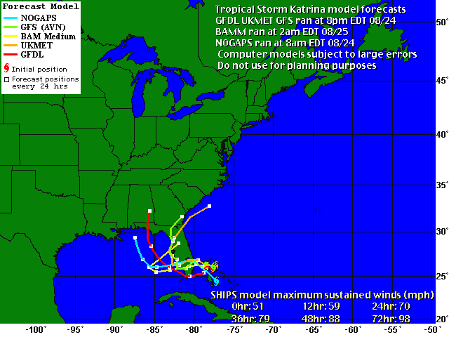
Katrina the Wanderer
 Katrina is giving the weather computers fits. The NHC discussion this morning indicated that none of the models have been able to track Katrina accurately. The current track is a blend of models, but since none have been able to forecast its motion accurately...all bets are off as far as I'm concerned. Not that I think it will hook east like Charley did last year, but who knows? The trouble with 'canes is they simply don't listen to weather forecasters.
 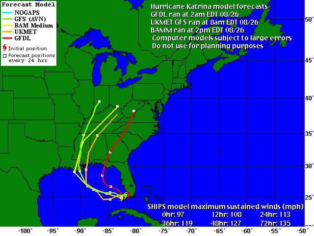 The computer models have shifted all over the dang map for the last couple of days. It's hard to have confidence in any of them. Note in this view from Weather Underground that three of the current models track Katrina further west, while one pulls it farther east. One thing is certain: Katrina's movement depends on a ridge of high pressure currently over Texas. When it encounters a weakness in that system, it will turn west. It seems that no computer or human can predict when or where that will happen. Welcome to the wonderful world of hurricane forecasting. What a job. When I don't do my job, someone doesn't get their fart machine in time for Christmas. But no one dies for lack of a fart machine. Well, maybe your old uncle who insists on playing the "pull my finger" game at the dinner table, but he's probably an old fart who's time has come anyway. [Kidding...don't send me hate mail, please.]
I heard from our friend Phil up in the panhandle this morning. Here's what he had to say:
Hello and good mornin' guys... I smell a hurricane. Looks like things should start to deteriorate our direction (those of you in the West Panhandle), sometime Sunday evening into early morning Monday, if the current forecast holds true. I could sure use the overtime, but I've found it unbelievable how many tropical cyclones have affected the region over the past 54 weeks, and I'm beginning to wonder how well Florida can take too many more of these. Just for giggles, the eye of Katrina passed over NHC last night. (Rebuilt after Andrew in 1992, located on Florida International University's South campus.)Thanks for the update, Phil. We'll be keeping an eye on y'all this weekend.
Prepare to bunker down ladies, Katrina is lookin' rather sexy as she wakes up this mornin'... Katrina gave Miami a good blow job, and I don't mean the vulgar kind so get your minds out of the gutter :-P
God Bless,
Phil
I'm a bit worried that I haven't heard from Bryan in Fort Lauderdale...Bry, if you're out there, honey, give me a shout, please? I'm worried about you...
Stay safe everyone. The Hunker Bunker is officially open for the weekend. Let's play guitars and watch the wind blow! The Florida Room is concert ready. We have movies, popcorn and food. Someone wanna bring the beer?
Thursday, August 25, 2005
Hurricane Katrina
Katrina is now a hurricane and set to make landfall near Ft. Lauderdale.
And this response to this morning's post from Phil:
HURRICANE KATRINA TROPICAL CYCLONE UPDATEOh, we're having fun NOW!
NWS TPC/NATIONAL HURRICANE CENTER MIAMI FL
335 PM EDT THU AUG 25 2005
...RECONNAISSANCE AIRCRAFT REPORTS AND DOPPLER RADAR DATA INDICATES THAT TROPICAL STORM KATRINA HAS STRENGTHENED INTO A HURRICANE...
SHORTLY BEFORE 330 PM EDT...REPORTS FROM A NOAA RECONNAISSANCE AIRCRAFT AND NOAA DOPPLER RADAR DATA FROM MIAMI INDICATE MAXIMUM SUSTAINED SURFACE WINDS INCREASED TO A CATEGORY ONE HURRICANE.
And this response to this morning's post from Phil:
Uhm.... If that thing hits anywhere between here and the Eastern Time Zone, I will likely be getting overtime at work.I'm sure he'll keep us posted over the weekend.
Hey I just noticed something.... Bonnie Charlie Frances Ivan Jeanne.... Arlene Cindy Dennis Katrina... one more and we will have matched last year in Florida-affecting named storms.
God Bless,
Phil
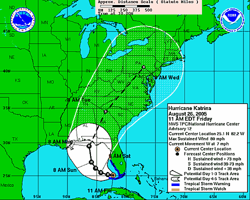
Katrina Set to Pound Florida's East Coast
 From the National Hurricane Center:
 A HURRICANE WARNING REMAINS IN EFFECT FOR THE SOUTHEAST FLORIDA COAST FROM VERO BEACH SOUTHWARD TO FLORIDA CITY...INCLUDING LAKE OKEECHOBEE. A HURRICANE WARNING MEANS THAT HURRICANE CONDITIONS ARE EXPECTED WITHIN THE WARNING AREA WITHIN THE NEXT 24 HOURS. PREPARATIONS TO PROTECT LIFE AND PROPERTY SHOULD BE RUSHED TO COMPLETION.Katrina is now about 90 miles east of Ft. Lauderdale and moving slowly toward the Florida peninsula. Bryan, you take care of yourself out there in FTL! Text me and let me know how it's going.

The NHC has revised yesterday's forecast and now warns that Katrina will likely become a category one hurricane before it makes landfall. Yesterday they had predicted that Katrina would be a tropical storm at first landfall on the peninsula and then strengthen to a hurricane over the warm Gulf water (93 degrees!!!) before it hits Florida again somewhere along the panhandle.
The computer models shown in this image [courtesy of Weather Underground] are in pretty good agreement about the first landfall, but once Katrina gets out over the Gulf of Mexico, it's hard to say where it will go. There's little doubt that it will become a hurricane again before second landfall, so everyone in the cone should be preparing for the worst while hoping for the best.
To our subscribers and friends in the Panhandle: we're all hoping Katrina turns in any direction but yours. Here on the Sun Coast, we're agreed that you've been through quite enough in the last 12 months. If the storm does hit there, hopefully, Phil will be in touch with Hurricane Land to let us know what's going on.
We'll be watching the storm all weekend. It's not like there will be anything else to do! Stay tuned. We're just getting warmed up in Hurricane Land.
Wednesday, August 24, 2005
TD 12 - Come on Down!
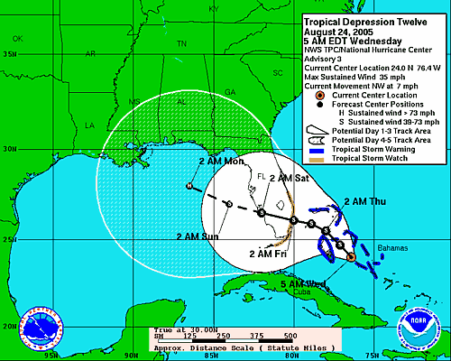 Tropical Depression 12 is set to hit Florida this weekend (but of course) as a tropical storm. Its name will be Katrina. The NHC forecast says the storm will hit the east coast and then travel across the state. It probably won't be much more than a nasty summer storm by the time it hits our side of the state, but it will be enough to thoroughly piss on our weekend.
 We're not planning to board up; we're just going to rent some movies and lay low.
It's probably just as well that it's a weekend storm. With the red tide killing everything that swims and flies at the beach, it hasn't been much of a recreational summer anyway. Boating is miserable and walking the beach is like smoking two packs of cigarettes in an hour. I suppose that's just as well, too, because it makes it harder to smell the dead fish, which far outnumber human beachgoers this year. It's just plain nasty out there.
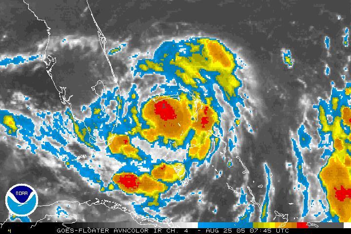
Meanwhile, the tropics are really starting to heat up now.
 The satellite image shows a lot of disturbance coming off the Cape. We expect the next few weeks to rock and roll in the tropics. We're ready. The hurricane kit is stocked and packed. Shutters are inspected and ready to install. Run or stay, we're ready.
 For those of you out west: don't worry. TD 12 (Katrina) isn't likely to do much but drop a lot of rain and maybe blow out some dead brush, which will save us the trouble of cutting it.
For those of you (you know who you are) who come up here for shelter or diversion during the storms: the Hunker Bunker is open for the weekend.
Thursday, August 18, 2005
Tasty Morsel Update
Note: This post should have published on the 17th, but didn't...apologies.
Phil, a reader and avid weather watcher like myself, says this of the tasty morsel from the earlier post:

Phil, a reader and avid weather watcher like myself, says this of the tasty morsel from the earlier post:
I found that cake on Webshots... and my immediate guess is that ERAU is Embry-Riddle Aeronautical University... They indicated that it was indeed a hurricane party.Thanks for clearing that up, Phil. And here I thought it was for a wedding. But then again, I was up at 4:30am because of last night's relentless thunderstorms. Not that I'm complaining...we've had very little rain this rainy season, which makes it unbearably hot -- even for me. I don't believe I ever used the phrase unbearably hot until this summer, but now...I have this to say: I give! I give! Uncle! Uncle! It's too hot even for me. Temps have been in the mid-nineties, but with humidity hovering at about 9,000%, the local weatherheads say the heat index is around 105 most days. I beg to differ. Seems to me the heat index has been about "face of the Sun" most days lately. And with the lovely toxicity of the lingering red tide algae bloom, catching a breeze at the beach is about as pleasant as catching bronchitis.
Phil
Wednesday, August 17, 2005
New Forecast from Dr. Gray, Irene and a Tasty Morsel
Dr. Gray and team revised their forecast earlier in the month. I've been away from the blog for a while due to...well...stuff. Here's the revised hurricane season forecast. Regular readers will recall the First Day of Hurricane Season post where this table was first posted. I've updated the table for this post. Note the regional strike probabilities have been revised upward as well.  Meanwhile, the tropics are looking eerily quiet. Tropical Depression Ten is still viable, but looks pathetic and weak spinning out there under all that shear. The NHCwarns that the storm could redevelop and advises the Northern Leeward Islands and the Virgin Islands to monitor TD 10's progress. The storm could redevelop into a tropical depression within a day or so as the low moves away into a more favorable environment for development. Even so, it looks unlikely that it will affect Florida.
 Good NIGHT Irene. This one is the storm that just won't die. It's weakened now to a tropical storm. Irene is what is known as a "fish storm." It will stay in the ocean (good place for it if you ask me) and die at sea.
 And finally, I received this tasty picture from a subscriber this morning. A weddding cake? Or just celebrating Hurricane Frances? Seems unlikely, but hurricane mania does the strangest things to people. [Phil: Care to explain the photo?]
NOTE: If the email is hard to read, you can access the entire post at: News From Hurricane Land. Stay tuned for more from the tropics.
To see previous landfall probabilities check out the First Day of Hurricane Season post.
2005 Forecast Forecast Activity as of: 12/03/04 04/01/05 08/05/05 Named Storms (NS) (9.6) 11 13 20 Named Storm Days (NSD) (49.1) 55 65 95 Hurricanes (H)(5.9) 6 7 10 Hurricane Days (HD)(24.5) 25 35 55 Intense Hurricanes (IH) (2.3) 3 3 6 Intense Hurricane Days (IHD)(5.0) 6 7 18 Net Tropical Cyclone Activity (NTC)(100%) 115 135 235 Check the right sidebar for a 2004 comparison and link to last year's scoreboard.
Revised Regional Probability Forecast:
Probabilities For At Least One Major (Category 3-4-5) Hurricane Landfall On Each Of The Following Coastal Areas:
1) Entire U.S. coastline - 77% (average for last century is 52%)
2) U.S. East Coast Including Peninsula Florida - 58% (average for last century is 31%)
3) Gulf Coast from the Florida Panhandle westward to Brownsville - 44% (average for last century is 30%)
4) Above-average major hurricane landfall risk in the Caribbean - revised to include Bahamas
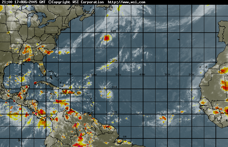 Meanwhile, the tropics are looking eerily quiet. Tropical Depression Ten is still viable, but looks pathetic and weak spinning out there under all that shear. The NHCwarns that the storm could redevelop and advises the Northern Leeward Islands and the Virgin Islands to monitor TD 10's progress. The storm could redevelop into a tropical depression within a day or so as the low moves away into a more favorable environment for development. Even so, it looks unlikely that it will affect Florida.
 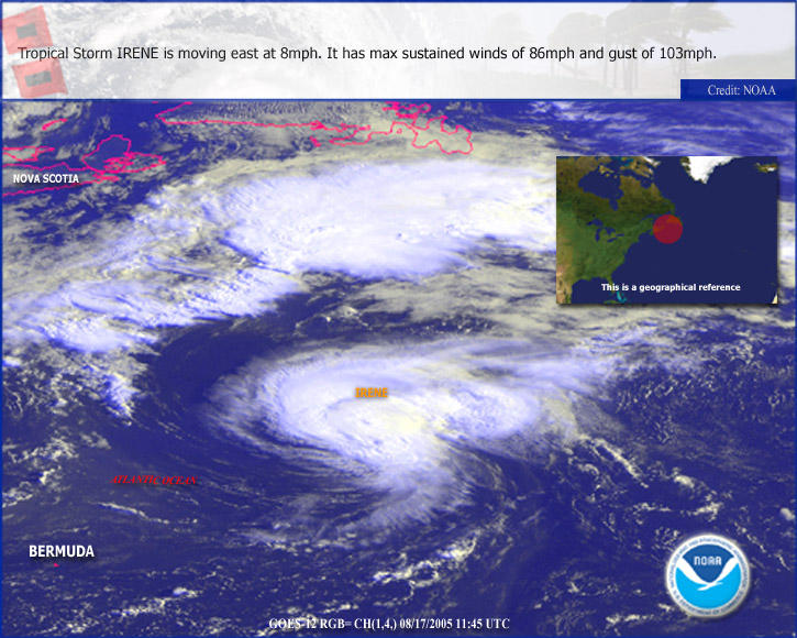 Good NIGHT Irene. This one is the storm that just won't die. It's weakened now to a tropical storm. Irene is what is known as a "fish storm." It will stay in the ocean (good place for it if you ask me) and die at sea.
  And finally, I received this tasty picture from a subscriber this morning. A weddding cake? Or just celebrating Hurricane Frances? Seems unlikely, but hurricane mania does the strangest things to people. [Phil: Care to explain the photo?]
 NOTE: If the email is hard to read, you can access the entire post at: News From Hurricane Land. Stay tuned for more from the tropics.
Subscribe to:
Posts (Atom)