Monday, October 24, 2005

Wilma Arrives in Florida

Statewide Doppler
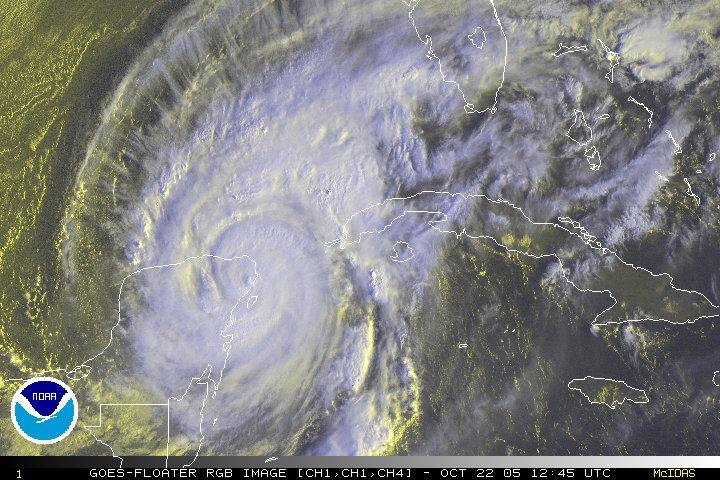
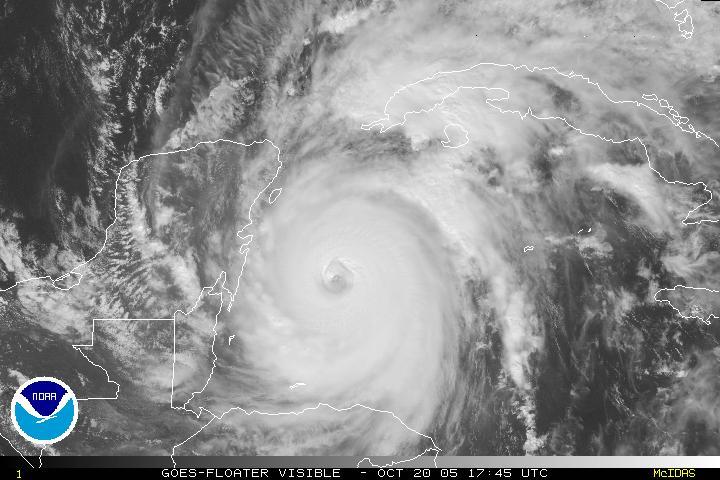
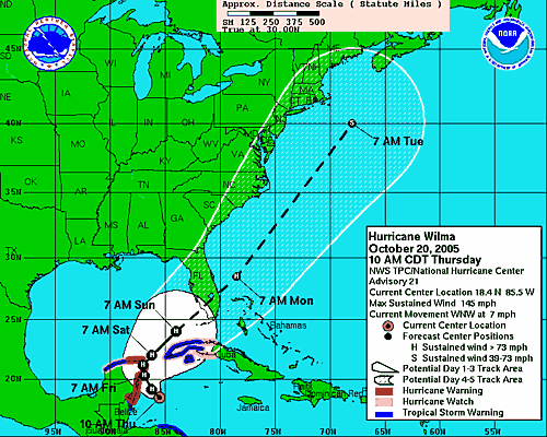
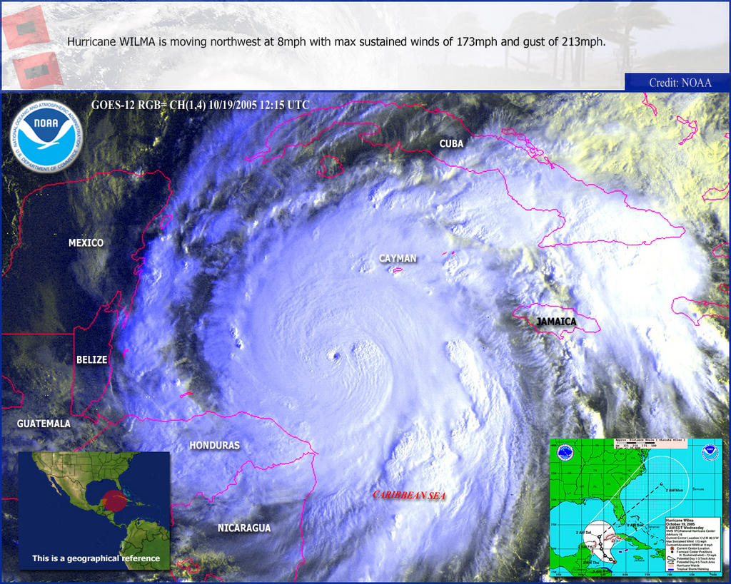
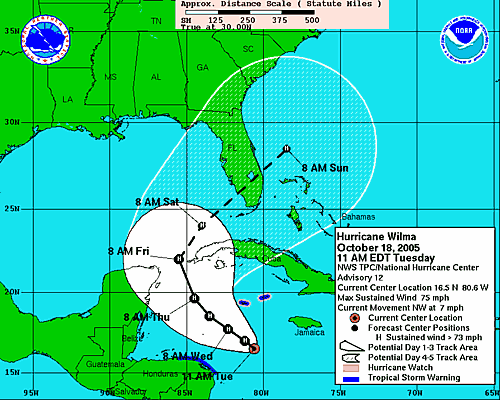
It's windy. Wilma came ashore as a category three hurricane about an hour ago at Marco Island, just south of Naples. (Wendy: I'm glad you evacuated!)

We're seeing tropical storm force winds with gusts brushing hurricane force in certain areas. We've been under tornado watch since last night. It's blowing pretty good out there, but we're spared the worst of it. Of course, schools are closed and no one is going to work today. We're supposed to get a cold front right after the storm, so the weather will go from tropical to winter in the space of a few hours. Right now it's humid and I can smell the warm rain through walls.

It's 7am and we're safe and dry. More later.

Saturday, October 22, 2005

Good Morning Wilma

Wilma, finished with Cozumel, slammed into the Yucatán peninsula. Because the storm is lingering, it could drop as much as 20 inches of rain on Cancún. Story...

Wilma RGBThe guidance models appear to be coming into agreement, making the NHC more certain of its forecast. However, the local news stations aren't in agreement as to whether Tampa is in the cone or not. Bay News 9 shows the cone just covering the edge of Manatee county, leaving Tampa out, but covering our area. The folks at Fox 13 News are broadcasting a broader cone, which agrees with the NHC's cone. So, while I cannot believe I am saying this: I believe Fox News.

State of EmergencyManatee County has declared as state of emergency, but we're not under any directions from emergency management officials. The NHC seems fairly certain of its forecast, but it also predicts a very large windfield as the hurricane gets pulled apart as it crosses the Gulf of Mexico.

Where does this leave us? Unknown. Right where we've been since Wilma was named. Watching and waiting. Any change in the steering conditions and the forecast could change in a heartbeat.

Stay tuned. We'll be spending most of the day preparing for the storm to hit us even though everyone says it's not going to. I know, I know. It's madness. Welcome to Paradise.

Friday, October 21, 2005

Wilma Slams Cozumel

wilma color
Wilma crashed into the shores of Cozumel this morning and is now headed for the Yucatán peninsula and Cancún. Story...

I don't know where our friends are at this point. Our attempts to reach them have failed. When we saw images of the shelters set up in Cancún, all we saw were tourists - no brown faces in the crowd. I hope their government is taking better care of them than ours did the poor citizens of New Orleans. Not surprisingly, Novedades, México's online newspaper seems to be offline. I guess we wait.

modelsMeanwhile, the uncertainty grows as to where and when Wilma will strike Florida's Gulf Coast. Workers are outside my window boarding up the top floor of our building. We are all taking precautions to safeguard our data in the event we take a direct hit. The map at left from Weather Underground's Steve Gregory shows that most of the models are still converging on South Florida while one stubbornly tracks north, predicting a Tampa Bay landfall. The NHC discussion indicates that the wide spread in the models so "both the location and the timing of the impacts on Florida remain very uncertain."

For this reason, I believe we will hang our hurricane shutters tomorrow - at least if I have anything to say about it, which I certainly do. Haha. The storm is just too unpredictable and I'd rather be shuttered in the calm than unprotected in the storm. So, the hunker bunker won't be open this weekend, but it will be open on Monday, if necessary.

To friends and family around the country and the world: try not to worry. We are smart, strong and prepared. We will do whatever it takes to weather the storm.

Thursday, October 20, 2005

Wicked Wilma

IR WilmaWilma is shaping up to be one of the nastiest storms on record. It will probably restrengthen to a category 5 before slamming into the Yucatán peninsula sometime tonight or tomorrow morning. I'm very worried about our friends in that area, but so far my attempts to contact them have failed. Hopefully, that means they are on their way away from the sea.

We are still taking a wait-and-see attitude toward hanging the shutters because Wicked Wilma has slowed some and we can't get a good read on whether it is worth the effort or not. We do expect to experience tropical storm force winds when Wilma crosses the state due to upper level conditions that will work to pull part of the storm to the north as it crosses Florida.

The models are now shifting even farther south, but Tampa Bay is still in the cone. Remember: don't focus on the line...you have to prepare if you are anywhere inside the cone. Preparation will make all the difference to your comfort and perhaps your survival in the event of a hit.

track


Remember:
Run from the water.
Hide from the wind.

Please stay safe everyone.

Wednesday, October 19, 2005

One Nasty Storm

wilma

Wilma: Cat 5

wilma models

Wilma became a category five overnight, but it is not expected to sustain its strength. It is expected to hit Florida, the 64-dollar question being: Where?

The "spaghetti models" are in pretty good agreement for a southerly landfall, but those of us who remember Charley remain skeptical, to say the least. You can see that only one of the models takes Wilma through Tampa bay, but that's enough to keep my attention. Jim and I will be watching carefully and preparing to board up and/or run, if necessary. Check back here for updates as I am able to post them.

The Hunker Bunker is tentatively open for business this weekend to our islander friends and those in low-lying Cortez. We have food, water, flashlights, board games and candles. Bring beer.

Tuesday, October 18, 2005

New Models - GFDL Shifts to the South

New Models GFDL, GFS and UKMET models have been updated. You can see that the GFDL, which had tracked Wilma up to Tampa Bay, has shifted south. The NOGAPS remains on a northerly track, but it hasn't run since 10pm yesterday. The NHC insists the models are in good agreement, so we'll have to wait to see what happens as the evening progresses and NOGAPS runs again.


Wilma TrackI strongly encourage everyone to keep in mind that we cannot focus on the tracks for either damage or exact landfall. We have to look at the cone and where we will be upon landfall. If you are on the Gulf Coast, you should be making preparations for both evacuating and hunkering down right now. Unless of course you enjoy getting in a fist fight with your neighbor over the last gallon of water at Winn-Dixie.

As Wilma approaches, remember the two rules:
1. RUN from the water
2.HIDE from the wind.
I will, of course, be watching carefully and keeping the site updated.

A note from Phil

Phil, friend of the list from the Florida Panhandle has this to contribute:
Hello....ltns.

Wilma also ties the record for the 21st significant Storm ... (back when we had 21 tropical storms or greater, was in the 1920's, when we werent yet naming them)..... but it ties that record, and that was the most active hurricane season on record...We are now all *OUT* of hurricane names, and the store doesn't get restocked until 2006. The Greek list is available, at a discounted clearance price.

God Bless,
Phil/Pensacola
Thanks, Phil. Looks like you'll be keeping an eye on the peninsula instead of the peninsula keeping an eye on y'all for this one. As always, I'll be watching...and yes, this time without my cigarettes! Hang on...we're goin' for a ride and I ain't talkin' hay ride.

Wilma Makes 12

Wilma Model
Wilma makes 12 hurricanes for 2005, tying the record set in 1969 for most hurricanes in a year. It's shaping up to be a nasty storm and I'm not liking the computer models much. Win lose or draw, Wilma will hit the Gulf Coast of Florida, giving the insurance companies more reason to stick it to us again, even if our neighborhood doesn't take a direct hit.

You can see from the models above that the NHC ia pretty confident of a Florida hit. It's just too soon to tell when, where and how sharply Wilma will turn before making landfall. The discussion points out that the intensity is tough to forecast, but the waters in the Gulf are about eight degrees lower than a month ago. To my way of thinking, that's good news for all of us.

We're just wondering if we're going to be spending Friday night and all day Saturday putting up our shutters. It's sure starting to look like it. I guess we'd better prepare the hunker bunker.

And the fun never ends in Hurricane Land...

Sunday, October 16, 2005

Shutters? In October?

TD 24
Here comes Wilma. Unbelievable. The NHC discussion this morning predicts strengthening to 88kt within 96 hours, which means we now have another major hurricane headed for the Gulf of Mexico. Simply unbelievable. When TD #24 is named, and I fully believe it will be, it will be called "Wilma." That's the last name on the list for 2005 boys and girls. After that, we have to go to letters in the greek alphabet. Is it just me or is it disconcerting to think of hurricanes called "Alpha" and "Omega"?

Hold tight kiddies. Wilma's here to remind you that hurricane season ain't over until it's over.