 Sorry I missed posting yesterday (it's a long story and more about me than you want to know) as Dennis jogged west and then east again. All in all, an exciting day for the ol' Menace.
High pressure is holding over the Florida peninsula, so it appears at this time that Dennis is will skirt the west coast of the peninsula and make landfall on the north gulf coast somewhere between Louisiana and the Florida panhandle. Though we are currently outside the "cone" of uncertainty, this storm still bears watching as is has joggged east to west and back several times already.
Dennis made landfall at Hispaniola yesterday and is currently pounding Cuba. A t least four people were killed in Haiti when a bridge collapsed and mud slides are said to have taken several lives in both Haiti and Jamaica, but the information coming out of the region is still spotty.
In this image, you can see Dennis's violent
 storms heading over Cuba. According to the Associated Press, Dennis packed 150 mph winds as it tore through Guantanamo, knocking down a guard tower at the U.S. terrorist prison camp there.
Evacuations have been ordered for the Florida Keys and tropical storm and flood warnings and watches have been posted for the southern Gulf coast of Florida. A tropical storm watch has been posted for our neighborhood as has a flood watch for both Saturday and Sunday. The local weather forecasters say we can expect high seas, high winds and lot of rain.
Though we aren't expecting a direct hit in the Tampa area, the track could change at any moment as we learned last year with Charley.
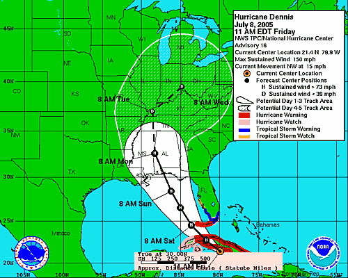
 The picture at left shows Dennis' east-west jogs over the last 36 hours. (Courtesy TBO.com.) The course changes are caused by weak areas in the edge of the high pressure system currently in place over the peninsula. Since the strength of the pressure area is not uniform (as it appears on television graphics), as Dennis skirts the high pressure ridge, stronger pressure areas push the storm west while weaker pressure areas allow it to shift eastward. It's probably still too early to tell how close Dennis will come to the Florida Gulf coast. A direct hit is unlikely at this time, but not completely impossible.
Whether Dennis makes a direct hit or not, we expect to have a fairly crappy weekend. I have to say: I cannot handle another "weekend hurricane season." Every hurricane that hit our area last year came through on a weekend, including Labor Day. I mean, we don't get "snow days" at work in Florida; we should get at least one or two "hurricane days."
We're not planning to shutter the house unless there is a dramatic shift in the projected track tonight, but we will open the Hunker Bunker this weekend for our friends on the island or nearer the Gulf who tend to lose power and/or water even in tropical storm force winds. (You know who you are. No need to call...just come on by.)


No comments:
Post a Comment