Saturday, July 30, 2005

Hurricane Survival Guide: Chapter One Published

I published Chapter One: Two Rules of the Florida Hurricane Survival Guide for Newbies on a new blog. This way, you don't have to receive the whole post in your inbox if you're not inclined to read it.

If you missed the Introduction: How We Got Here From There, you can read it here...

When I publish the next chapter, I will post a link on News From Hurricane Land instead of posting the entire text. I'm doing this to separate my smart assy book from my smart assy news on the season and to show mercy to you...my valued subscribers.

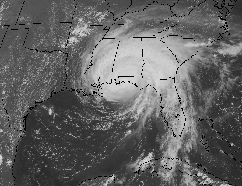
Today the tropics are quiet with the exception of a tropical wave that doesn't appear to be developing into anything stronger. The NHC says conditions don't look good for the wave:
TROPICAL WEATHER OUTLOOK
NWS TPC/NATIONAL HURRICANE CENTER MIAMI FL
530 AM EDT SAT JUL 30 2005

FOR THE NORTH ATLANTIC...CARIBBEAN SEA AND THE GULF OF MEXICO...

SATELLITE IMAGES...SURFACE OBSERVATIONS AND RADAR FROM PUERTO RICO INDICATE THAT INDICATE THAT THE AREA OF LOW PRESSURE ASSOCIATED WITH THE TROPICAL WAVE IS LOCATED BETWEEN PUERTO RICO AND HISPANIOLA. THIS SYSTEM HAS NOT BECOME ANY BETTER ORGANIZED SINCE YESTERDAY AND UPPER-LEVEL WINDS ARE NOT FAVORABLE FOR SIGNIFICANT DEVELOPMENT. ALTHOUGH THE POTENTIAL FOR THE FORMATION OF A TROPICAL DEPRESSION HAS DIMINISHED...SQUALLS PRODUCING BRIEF PERIODS OF HEAVY RAINFALL AND STRONG GUSTY WINDS...ESPECIALLY OVER HIGHER TERRAIN...ARE POSSIBLE OVER THE VIRGIN ISLANDS...PUERTO RICO...AND HISPANIOLA TODAY. AN AIR FORCE RESERVE UNIT RECONNAISSANCE AIRCRAFT IS SCHEDULED TO INVESTIGATE THE SYSTEM THIS AFTERNOON...IF NECESSARY.
As you might imagine, this news does a lot to relieve our tropical depression.

Tuesday, July 26, 2005

News from...er...Dust Land?

African Dust StormFrom NASA, this image shows a dust storm blowing off the coast of Africa that is supposed to reach Florida today. According to local meteorologists, the affects will be minimal. We're supposed to have more vibrant sunrises and sunsets, but forecasters don't expect the storm to affect air quality. However, individuals with asthma and other respiratory problems might experience some difficulty as the dust makes its way over the peninsula. Story

Apparently, this is a common summer phenomenon. More about dust storms from NASA. Saharan dust also affects the intensity of Florida thunderstorms. Story from NASA

Here's a pretty cool slide show from NBC6.

And of course, no meteorological story would be complete without a complete disagreement among experts. Kevin Lollar of the News-Press says the Dust mass should miss us.

Dust Storm 03 This is an image of a Sarahan dust storm over the Atlantic Ocean and Canary Islands taken on July 24, 2003. Courtesy: NASA

Meanwhile, in hurricane news, Tropical Storm Franklin spurs warnings for Bermuda and the last advisory is issued for Tropical Depression Gert as it dissipates over México.

Sunday, July 24, 2005

Tropical Storm Gert

We're working our way through the alphabet pretty quick this year. June isn't even over and we're up to G - for Gert, which looks as if it will hit México...right on the heels of the pounding they took from Emily.
From the National Hurricane Center
AT 7 AM CDT...1200Z...THE BROAD AND POORLY-DEFINED CENTER OF TROPICAL STORM GERT WAS ESTIMATED NEAR LATITUDE 21.1 NORTH...LONGITUDE 95.8 WEST OR ABOUT 155 MILES... 250 KM...EAST-SOUTHEAST OF TAMPICO MEXICO.

GERT IS MOVING TOWARD THE WEST-NORTHWEST NEAR 10 MPH...17 KM/HR...AND THIS MOTION IS EXPECTED TO CONTINUE FOR THE NEXT 24 HOURS. ON THE FORECAST TRACK...THE CENTER OF GERT IS EXPECTED TO REACH THE COASTLINE WITHIN THE WARNING AREA THIS EVENING.

MAXIMUM SUSTAINED WINDS ARE NEAR 40 MPH... 65 KM/HR...WITH HIGHER GUSTS. SOME STRENGTHENING IS POSSIBLE BEFORE LANDFALL.

TROPICAL STORM FORCE WINDS EXTEND OUTWARD UP TO 60 MILES... 95 KM FROM THE CENTER. ESTIMATED MINIMUM CENTRAL PRESSURE IS 1009 MB...29.80 INCHES.

TOTAL RAINFALL AMOUNTS OF 4 TO 7 INCHES...WITH ISOLATED AMOUNTS UP TO 10 INCHES OVER MOUNTAINOUS TERRAIN...ARE POSSIBLE ACROSS EASTERN MEXICO. THESE RAINS COULD CAUSE LIFE-THREATENING FLASH FLOODS AND MUD SLIDES...ESPECIALLY IN AREAS PREVIOUSLY AFFECTED BY HURRICANE EMILY.
Meanwhile, Franklin looks like it will be a fish storm. Hurricane or no, the beaches are still unusable here due to more red tide related fallout. See, the red tide kills fish. Sea birds eat the dead fish. Well, it seems the birds have been eating so well lately that the waters are now polluted with...you guessed it...bird shit.

Welcome to Paradise!

Friday, July 22, 2005

Tropical Storm Franklin Blows Up in the Caribbean

Franklin TrackTropical Storm Franklin (projected track at left) blew up almost over night it seems. It's not supposed to affect Florida, but recall Hurricane Jeanne? (Verified track at right.) That nasty storm spun out in the Atlantic for days before deciding it too wanted a crack at poor weather-beaten Florida.

For those who don't remember or didn't experience Florida's shattered collective psyche, here's a reminder from cartoonist Jeff Parker: Jeff Parker Cartoon - Hurricane Ivan 2004It seemed funnier between December and May somehow.

Meanwhile, Jim has finished cutting and fitting the remaining plywood shutters for our house. Last year, the boys actually framed in our most vulnerable windows instead of just laying flat plywood, but several went uncovered because we ran out of time or materials. The picture shows the front window framed in before the plywood is applied. It's like a wall outside the house and while it seemed like overkill, it turns out to be the strongest application we can make on our own. The less vulnerable windows will be covered with plywood affixed with Plylox clips. The image at right shows Austin and Jim with some scrap plywood we scrounged up somewhere. I don't even remember where we got it, just that whomever gave it to us had used the wood for a Halloween party. We're not all that superstitious, but we still turned the painted side in toward the window. No sense inviting disaster - it hardly needed an invite last year.

We're bracing for another season, trying to take care of ourselves and our neighbors. I'm less freaked out this year because I know what to do and how hurricanes work and what you can and can't do to save life and property. With knowledge, fear subsides. (Anyone read the allegory of the cave?)

Wednesday, July 20, 2005

Mailing List Trouble

My defection from Intense Host is complete and the mailing list trouble should be worked out, though your old passwords probably won't work with the new list. To change or receive your password by email, go to the subscribe page. I'm sorry for the inconvenience. Hopefully this will do it for tech issues this season. Ha!

Recent posts you might have missed:

México's Riviera Maya Takes Pounding from Emily

Hurricane Emily to Strike Cancún - Rich People Evacuating

Under the Bermuda High

Hurricane Repellent

Tuesday, July 19, 2005

México's Riviera Maya Takes Pounding from Emily

It appears that Cancún was spared a direct hit from the storm while further south less "touristy" resorts took quite a beating. Mexican officials said there was little damage to the ruins at Tulum but the backpacker hotels lost their roofs as did, apparently, some of the larger luxury hotels.
Story

This story is the first mention of any of the locals in the Riviera Maya region that I have seen in the US English language press. Apparently, many are now homeless. Story

We have not yet heard from any of our friends who live in Cancún, but the regional newspaper from the state* of Quintana Roo says that Cancún took mostly tree damage and that no injuries or deaths have been reported. I did my best to translate the story, but I'm far from fluent in Spanish.
Destruction of more than 50 kilometers of the electric network along the Riviera Maya, interruption of drinking water service, blocked highways, collapsed gas stations, antennae, trees and billboards, as well as flooding and damage to dwellings were left in the path of Hurricane Emily Sunday night and early Monday morning.

Along the Riviera Maya some weak dwellings were destroyed and trailers were overturned under the force of the hurricane that caused terror among inhabitants.

The hurricane, a category 4 on the Saffir-Simpson scale, made landfall in the the state of Quintana Roo between Xel Há and Tulum with sustained winds of more than 230 kilometers per hour and gusts of 285 kilometers per hour, devastating the territory between Playa del Carmen and Tulum.

Electric service has been out since 9:00 PM Monday and, as of Tuesday night, service had not yet been 100% restored.

Emily came ashore in the zone between Puerto Aventuras and Akumal, where two gas stations collapsed, a car was buried between two cement walls and a cell phone antenna [tower] came down. The preliminary estimate by authorities yesterday projected economic losses of over 600 million pesos [$60 million USD] along the Riviera Maya, including damages in Playa del Carmen.

It is important to emphasize that as of yesterday no human deaths or injuries were reported as a direct result of the storm. In Cancún and Cozumel, the damage done by Emily's hurricane-force winds were minor. The region reported road damage, some downed power poles and billboards and flooding in addition to the destruction of more than 450 trees.
If you read Spanish, you can read the full story or go to the
Novedades Home Page.

I know power and communications are down, so I'm hoping for the best, though we have not heard a word out of Cancún since the hurricane began to threaten.

* Quintana Roo is one of three states on the Yucatán peninsula. Yucatán is also a state on the peninsula, which causes some confusion. Campeche rounds out the trio. Quintana Roo's coastline is on the Caribbean Sea while both Yucatán and Campeche are on the Gulf of Mexico. Learn more

Monday, July 18, 2005

Emily Comes Ashore Near Tulum, México

Still no word from our friends...
HURRICANE EMILY TROPICAL CYCLONE UPDATE
NWS TPC/NATIONAL HURRICANE CENTER MIAMI FL
300 AM EDT MON JUL 18 2005

SATELLITE AND RADAR IMAGES INDICATE THAT THE CENTER OF HURRICANE EMILY MADE LANDFALL JUST NORTH OF TULUM MEXICO NEAR 0630Z...230 AM EDT THIS MORNING. THE ESTIMATED INTENSITY AT LANDFALL WAS 135 MPH...CATEGORY FOUR ON THE SAFFIR-SIMPSON SCALE. THE NORTHERN EYEWALL...WHERE THE WORST WEATHER WOULD BE EXPECTED...PASSED DIRECTLY OVER COZUMEL.
Tulum is about 100 miles south of Cancún. I wonder how the Mayan ruins will withstand the direct hit. We'll know more later tonight.

Sunday, July 17, 2005

Hurricane Emily to Strike Cancún - Rich People Evacuating

Courtesy NOAA

It appears Emily is going to take a bite out of our beloved Cancún. We're watching and thinking of our friends there. As you can imagine, housing in El Centro is not as sound as the hotels and villas built for tourist use both on Cancún Island - also known as the Hotel Zone - and along the coast from Cancún to Playa del Carmen. It sounds like evacuation efforts are focused on and maybe even reserved for tourists; I haven't seen anything about evacuation of the citizens who live in Cancún City. Imagine my surprise. The rich, white people get to leave before the poor, brown people. I know, it's just shocking, isn't it?
A massive evacuation of tourists in one of the world's largest resorts began Sunday, as hundreds of buses were dispatched to move tens of thousands of tourists away from Hurricane Emily, heading toward a direct hit on the coast.

The very size of the task was daunting: about 500 buses were ordered to move 30,000 tourists in Cancun - part of a total of 70,000 to 80,000 mostly foreign tourists to be evacuated statewide to temporary shelters in ballrooms and convention centers.

"We have very little hope that this will change course," said a grim-faced Cancun Mayor, Francisco Alor. "This hurricane is coming with same force as Gilbert," a legendary 1988 hurricane that killed 300 people in Mexico and the Caribbean. Full Story...
Emily is almost a category 5 storm now, with winds of 150 mph. Manuela, Jesus, Yanet...everyone: we are thinking of you. Cuidado amigos, cuidado.

Saturday, July 16, 2005

All Quiet In Florida...For Now

We're under the Bermuda High, which is keeping hurricanes away from us for the moment. Jim and I might even go on the Cortez Yacht Club's poker run today...the red tide is the only thing giving us pause for thought. Plus, we have a lot of work to do on the house still. We want to get our shutters in shape without doing it in a panic. The problem is, when it's finally nice like this, you want to enjoy paradise for a weekend. So, we'll probably do a little of both. A little work, a little play. In any case, it feels good to not have a storm making our decisions for us.

I am changing hosting companies this weekend. I've already made some of the changes, so my email and the Hurricane Land e-mail list will be disrupted for about 24-36 hours. (RSS feeds will continue to work normally.) I apologize for the inconvenience, but with Intense Host, my main site has been down more than up for the last couple of months. It wouldn't be so bad if they'd explain or let you contact them, but all you get is dead silence on their end. The 800 number is even blocked now. Seems like a good time to collect my files and move on. I was weary of talking to their tech support anyway. I'm switching to Surpass, which comes highly recommended and is cheaper. Hopefully, they will keep their servers up and running.

Thursday, July 14, 2005

Hurricane Repellent

There's a high pressure system in place over Florida, which is ensuring that Emily stays to our south.

Three cheers for high pressure! (Who knew that moving to Florida would make me into such a weather geek?)

Looks like a nice weekend for us, if we can stand the red tide, which incidentally was not cleared out by Dennis. In fact, it's worse than ever.
"One of the greatest losses resulting from the red tide that swept through much of lower Tampa Bay in recent weeks was the 16-year stockpile of Goliath grouper." [Known as Jewfish before the PC era. -Ed.]
See the rest of Frank Sargeant's fishing report "Goliath Grouper Wasted By Red Tide" for the tragically smelly details.

Meanwhile, the panhandle continues its cleanup effort and tries to put life back together after two major hurricane hits in less than a year.
Gulf Coast Cleans up from Hurricane Dennis.

Some people are just done with it: Repeat Hurricanes Have Some Panhandle Residents Planning to Leave. Unless you leave Florida entirely, you won't escape the hurricanes. Ask the people in inland Polk County; they got hit three times last year.

And this one from the "meaner than hell" + "what's wrong with unions" files: Transit Workers Fired For Not Helping Evacuations Get Jobs Back. Can you feel the love? These folks wouldn't survive a day in our community. They'd be shunned for life. In fact, some of us might just take them out for a nice blanket party. Who refuses to help their neighbor when a hurricane is closing in? Assholes, that's who.

And the Florida tourism PR machine is back in business as well: Florida welcomes visitors post-hurricane Dennis.

In future news: another small area of disorganized storm activity appears to be forming, but is not expected to develop much until it reaches warmer waters:
TROPICAL WEATHER OUTLOOK
NWS TPC/NATIONAL HURRICANE CENTER MIAMI FL
1130 AM EDT THU JUL 14 2005

THE TROPICAL WAVE LOCATED MIDWAY BETWEEN AFRICA AND THE LESSER ANTILLES REMAINS DISORGANIZED THIS MORNING. ALTHOUGH UPPER-LEVEL WINDS ARE ONLY MARGINALLY FAVORABLE FOR TROPICAL CYCLONE DEVELOPMENT...THE WAVE WILL BE MOVING OVER WARMER WATERS OVER THE NEXT DAY OR TWO AND SOME SLOW DEVELOPMENT OF THIS SYSTEM IS POSSIBLE.

ELSEWHERE...TROPICAL STORM FORMATION IS NOT EXPECTED THROUGH FRIDAY.

FORECASTER FRANKLIN
We will be, as always, monitoring the wave and hoping that our hurricane-repelling high pressure stays in place.

Wednesday, July 13, 2005

Outside the Cone

Florida is outside the cone for a change. Outside the cone is a lovely place to be. It gives us additional time to prepare for the next storm. We are getting an estimate on a hurricane door for our garage. I didn't much like the way the old door behaved when Dennis' winds came crashing up from the south, so we're looking at getting a "wind kit" or just upgrading the whole door.

The garage door, because it is such a large opening, is the Achilles heel for most homes. Once the wind enters your home, the roof comes off. Once the roof comes off...well, you're toast. Wet toast, but toast just the same. I will explore this more in the coming chapters of my book, which will be posted as hurricane activity allows me time to edit and proof them.

It looks like Emily might crash into the Yucatan, which is hard for us to watch as we have friends on that peninsula, too. Manuela, Jesus Yanet, Alfredo, Yurson and Estrella: we're thinking about you.

As of now, the winds are not strengthening and hurricane watches and warnings have been downgraded to tropical storm advisories for the southern windward islands. Emily is not expected to reach hurricane strength before clearing the islands tonight as predicted earlier.

Tuesday, July 12, 2005

Good Morning Emily


BULLETIN
TROPICAL STORM EMILY ADVISORY NUMBER 7
NWS TPC/NATIONAL HURRICANE CENTER MIAMI FL
11 AM AST TUE JUL 12 2005

...EMILY STRENGTHENING...HURRICANE WATCHES ISSUED IN THE WINDWARD ISLANDS...

AT 11 AM AST...1500Z...HURRICANE WATCHES HAVE BEEN ISSUED FOR BARBADOS...GRENADA...THE GRENADINES...ST. VINCENT...AND ST. LUCIA...BY THE APPROPRIATE GOVERNMENTS. A HURRICANE WATCH MEANS THAT HURRICANE CONDITIONS ARE POSSIBLE WITHIN THE WATCH AREA WITHIN 36 HOURS.

AT 11 AM AST...THE GOVERNMENT OF TRINIDAD HAS ISSUED A TROPICAL STORM WATCH FOR THE ISLAND OF TOBAGO. A TROPICAL STORM WATCH MEANS THAT TROPICAL STORM CONDITIONS ARE POSSIBLE WITHIN THE WATCH AREA WITHIN 36 HOURS.

INTERESTS ELSEWHERE IN THE EASTERN CARIBBEAN SHOULD MONITOR THE PROGRESS OF EMILY.
Sigh...

Monday, July 11, 2005

Tropical Depression # 5

TD 5 PathTropical depression #5 has formed out of a tropical wave off of Cape Verde. It is forecast to become a tropical storm within the next 24 hours (by early morning on July 12). Its name will be Emily. It's too early to tell where it's headed.

Meanwhile, Gulf Coast residents are recovering from a direct hit from Dennis. Though it was still a hurricane when it made landfall, it had weakened to a category three and moved through the area quickly.
Damage Reports

There's a reason there are so many mobile homes in Florida (besides the large number of retiree-owned second homes). The state, supported by the elitist, bought-and-paid-for legislature and our illustrious anti-worker governor, is fundamentally opposed to paying a living wage. If you can't afford to rent a house, apartment or one of the ugly Florida condos that seem to multiply like maggots even as we sleep, your choices are pretty much living in your car or in a mobile home. (The choices are similar if you think about it. The mobile home is more spacious, but you can't pack up and drive it to Georgia when a hurricane threatens.) When a storm comes, those who need protection most are often lack the resources to even run and hide, let alone rebuild: Low -income Residents Hit Hard. If there is anything you can do to help someone in your immediate area...

The damage wasn't as bad as most had feared...
Dennis leaves modest damage in weary Florida

Though the storm has been over for less than 24 hours, the clean-up has already begun: Clean up Begins

And in the wake of the storm, the Florida panhandle looks again like paradise: A Perfect Monday Morning

As for our next storm, the NHC says:
"While there is presently some easterly shear with this system... as well as marginal thermodynamics ...the environment is expected to become more favorable for development in both regards over the next few days. Given this...slow but steady strengthening is anticipated over the next 72 hours...and the official forecast is in good agreement with ships and GFDL guidance. The GFDL...which develops the depression only slowly at first...continues to make the cyclone a significant hurricane in the Caribbean." --FORECASTER FRANKLIN
For an up-to-date "spaghetti model" view: Weather Underground.
For an explanation of the models: National Hurricane Center (NOAA)

Spaghetti Models
From this morning's NHC discussion of TD #5:
"The official forecast ... which is a little south of the previous forecast...is a blend of the GFDL and NOGAPS models. It is perhaps of interest to note that the NOGAPS ... which had only a so-so year last year ... is currently the best performing Atlantic track model so far in 2005 ... and the FSU Superensemble...which won hands down last year ... is struggling a bit." --FORECASTER FRANKLIN
NOGAPS is represented above in blue and GFDL is represented in red. The storm is currently about 1200 miles east of the windward islands with maximum sustained winds of 35 mph.

Sunday, July 10, 2005

Dennis Makes Landfall In Florida

Dennis Makes Landfall
Hurricane Dennis has made landfall on Santa Rosa Island between Navarre Beach and Pensacola Beach, Florida. The local news reported sustained winds of 120 mph, which means Dennis was a category three 'cane as it came ashore. Our thoughts and hopes are with the people in Dennis' path right now. More info...

On the peninsula, the worst is over. It's hot again. The sun peeks out every now and then. The wind still howls faintly, but the storm has mostly passed.

For news on how the Tampa Bay area fared Bay News 9 has some decent coverage.

Feel compelled to help? Try the Red Cross National Disaster Relief Fund. It's tax deductible.

But wait, there's more...


TROPICAL WEATHER OUTLOOK
NWS TPC/NATIONAL HURRICANE CENTER MIAMI FL
1130 AM EDT SUN JUL 10 2005

FOR THE NORTH ATLANTIC...CARIBBEAN SEA AND THE GULF OF MEXICO...

THE TROPICAL WAVE LOCATED ABOUT 1250 MILES EAST OF THE LESSER ANTILLES CONTINUES TO SHOW SIGNS OF ORGANIZATION....AND THIS SYSTEM HAS THE POTENTIAL TO DEVELOP INTO A TROPICAL DEPRESSION DURING THE NEXT DAY OR TWO AS IT MOVES WESTWARD AT 10 TO 15 MPH.
Hang on. We're in for a wild summer.

Hurricane Dennis Drenches Gulf Coast

Dennis is now a category four hurricane. Our hearts and minds are with our fellow hurricane-weary souls on the northern Gulf Coast, where the impact of Dennis will be catastrophic -- at best. The forecast track takes it right to the folks who suffered through Ivan last year. I can't imagine the horror of watching Dennis approach now. All I can say is that the peninsula feels for you; we're watching and praying.

The storm is a couple hundred miles out to sea, yet it managed to deliver some nasty weather, including tornadic activity and flooding to the Sun Coast. We woke up to howling wind and pounding rain at about 5:00 this morning. As the outer bands pass through, we get small tornadoes, waterspouts and some microburst activity throughout the area. We opened the hunker bunker yesterday, but it wasn't necessary. It was really just an excuse to party and eat Chef James' cooking.

Flooding is a major concern on the barrier islands and near the intracoastal waterways. The picture at right shows this morning's high tide in Cortez. Sarasota Bay has pretty much taken over our friend's yard. Good thing he's the Captain; he's going to need a boat to get out of there today.

Our friend who lives on Anna Maria Island just called and said the beach where we always frolic is gone. "The water is right up to the steps of the houses and some of the rocks [that form a retaining wall there] are just gone," he said.

He's worried about the next storm...all of us are worried. This radar image from intellicast.com shows the energy just streaming off of the coast of Africa and strong thunderstorms building once again near the Caribbean Sea. The question isn't if we will have another hurricane, but when.

Though it's been a bad tropical storm, Manatee County has had very minimal damage and flooding. We were lucky. Again. But after last year's season, no one seems quite ready to breathe a sigh of relief. Maybe in November.

Saturday, July 09, 2005

Hurricane Dennis Update

Courtesy NOAA
Dennis RGB Dennis is brushing past the Florida Keys and pounding Key West with sustained tropical storm force winds and gusts nearing 70 mph. Power is out all over Key West and damage reports are coming in already. Many people there are still rebuilding from last year as are the people who are now preparing for a direct hit on the northern Gulf coast. Landfall is projected between the western Florida panhandle and the short stretch of Alabama coastline, both of which got slammed last year by Ivan.

As Dennis passed over Cuba, it weakened from a category four to a category one hurricane. Now that it has emerged into the Gulf of Mexico, it is beginning to restrengthen and is now a category two. It's expected to continue gaining strength over the warm Gulf, which is a hurricane-feeding 90 degrees right now.

We had some intense squalls last night as the outer band of Dennis passed over us and a repeat performance this morning when another band passed through. We're on the dangerous side of the storm, so depending on how far east Dennis tracks, we could see some tornadic activity and perhaps even some microbursts. We're hoping Dennis continues its westerly motion as it makes its way north, which will keep it a few hundred miles offshore. We'll still see high water and Anna Maria Island will likely see some flooding. Inland areas still suffering from heavy rainfall and rivers above flood stage will be the hardest hit.

We're in for more squalls and bad weatherTampa Local Radar overall, to be sure. The lightning has been very intense, but the winds haven't been too bad yet. The radar picture at right (courtesy baynews9.com) shows the intense activity as the bands pass over the Florida peninsula.

The only bonus here is that the storm might help clear out the red tide that has been plaguing us since February. Or, according to the Bradenton Herald, the storm could provide it with just enough fresh water to create additional nutrients. Read more from the Herald...

Red tide is a toxic algae bloom that the press and state officials downplay because they don't want to scare off the tourists. As if a beach reeking of dead fish wouldn't drive people away. Besides killing fish and marine mammals, red tide causes respiratory problems in land mammals, like humans. Neither the short nor the long term effects of exposure to red tide are understood, but the mainstream media will tell you that red tide is not dangerous. Of course you can still go swimming and fishing. Just don't swallow the water or eat any shellfish. And if you start to cough and sneeze and feel like you're choking to death, you should probably leave the beach. Um...duh.

Our own Mote Marine is trying to understand how red tide affects humans, but the data is incomplete and so far inconclusive. Okay, this isn't News from Red Tide Land, so I'll stop there.

More later as Dennis continues churning up the Gulf coast.

Friday, July 08, 2005

This Just in From Cuba

HURRICANE DENNIS TROPICAL CYCLONE UPDATE
NWS TPC/NATIONAL HURRICANE CENTER MIAMI FL
310 PM EDT FRI JUL 08 2005

Reports from the Cuban Meteorlogical Service and Civil Defense through HAM radio operators indicate a wind gust to 149 MPH occurred at Cienfuegos, Cuba around 1:30 PM EDT. More than 85 percent of the powerlines were down and extensive damage has occurred to the communications infastructure.

FORECASTER STEWART

Link

A Very Pretty Picture of Hurricane Dennis

From the NOAA Satellilte and Information Service: Operational Significant Event Imagery

Dennis: Category Four Menace

Courtesy NOAA
Sorry I missed posting yesterday (it's a long story and more about me than you want to know) as Dennis jogged west and then east again. All in all, an exciting day for the ol' Menace.

High pressure is holding over the Florida peninsula, so it appears at this time that Dennis is will skirt the west coast of the peninsula and make landfall on the north gulf coast somewhere between Louisiana and the Florida panhandle. Though we are currently outside the "cone" of uncertainty, this storm still bears watching as is has joggged east to west and back several times already.

Dennis made landfall at Hispaniola yesterday and is currently pounding Cuba. A t least four people were killed in Haiti when a bridge collapsed and mud slides are said to have taken several lives in both Haiti and Jamaica, but the information coming out of the region is still spotty.

In this image, you can see Dennis's violent storms heading over Cuba. According to the Associated Press, Dennis packed 150 mph winds as it tore through Guantanamo, knocking down a guard tower at the U.S. terrorist prison camp there.

Evacuations have been ordered for the Florida Keys and tropical storm and flood warnings and watches have been posted for the southern Gulf coast of Florida. A tropical storm watch has been posted for our neighborhood as has a flood watch for both Saturday and Sunday. The local weather forecasters say we can expect high seas, high winds and lot of rain.

Though we aren't expecting a direct hit in the Tampa area, the track could change at any moment as we learned last year with Charley. The picture at left shows Dennis' east-west jogs over the last 36 hours. (Courtesy TBO.com.) The course changes are caused by weak areas in the edge of the high pressure system currently in place over the peninsula. Since the strength of the pressure area is not uniform (as it appears on television graphics), as Dennis skirts the high pressure ridge, stronger pressure areas push the storm west while weaker pressure areas allow it to shift eastward. It's probably still too early to tell how close Dennis will come to the Florida Gulf coast. A direct hit is unlikely at this time, but not completely impossible.

Whether Dennis makes a direct hit or not, we expect to have a fairly crappy weekend. I have to say: I cannot handle another "weekend hurricane season." Every hurricane that hit our area last year came through on a weekend, including Labor Day. I mean, we don't get "snow days" at work in Florida; we should get at least one or two "hurricane days."

We're not planning to shutter the house unless there is a dramatic shift in the projected track tonight, but we will open the Hunker Bunker this weekend for our friends on the island or nearer the Gulf who tend to lose power and/or water even in tropical storm force winds. (You know who you are. No need to call...just come on by.)

Wednesday, July 06, 2005

Cindy Hits Louisiana...Greedy Oil Men Hit all of Us

Correction to this post and thank those of you who pointed it out...I don't know what I was thinking...I know the Saffir-Simpson Scale by heart. Cindy came ashore at 70mph, 4mph short of hurricane strength...

Tropical Storm Cindy was near hurricane strength at 112 70 mph before making landfall near New Orleans. Hurricane strength is defined as sustained winds of 119 74 mph. I bet those Louisiana folks were counting their blessings that it wasn't a hurricane.

Cindy flooded streets, tore down power lines and twisted trees in the historic French Quarter district of the Mardi Gras city and left about a 1/4 million people without power throughout Louisiana. She dumped about ten inches of rain on the region on her trek inland.

Meanwhile, the headline in Forbes is: "Oil Prices Top $60 a Barrel on Storm Fears." While it's certain that drilling operations in the Gulf of Mexico were suspended and production might just suffer a little bit, let's get a grip folks. This was an itty-bitty storm. Itty-bitty-Teeny-weeny storm. If this is what we have to look forward to this season, we'll be at $5 per gallon at the pumps in no time. (Personally, I'd pay $10 a gallon if they'd stop drilling in our beautiful Gulf. But I'm pretty sure that's just me. Sigh.) Read the story...

Cindy is now just a tropical depression, a term that begins to take on many meanings in Florida at this time of year. But wait! There's more! We also get this fabulous Tropical-Storm-Soon-To-Be-Major-Hurricane named Dennis. At no extra charge!

All the forecast tracks so far say Dennis will hit the Florida Panhandle. But, funny (peculiar, not ha-ha) thing about hurricane tracks: hurricanes don't always follow them. Ask Port Charlotte. So, if you're in Florida, you're in the cone of uncertainty at this point and you can't afford to take it lightly. More on Dennis in the next post...

Tuesday, July 05, 2005

Named Storm #4: Dennis

Courtesy NOAA

As predicted, TD #4 became Tropical Storm Dennis this morning. The five-day path shows Tampa Bay in the "cone of uncertainty," meaning it could strike here or not.

By all accounts, Dennis should be our first hurricane of the season.

Something tells me we'll be spending some quality time with plywood and tapcons this weekend. And so it begins...

Tropical Storm Cindy and Warming up for Dennis

Cindy and DennisCindy is about right in the middle of the Gulf of Mexico, projected to make landfall somewhere along the coast of Louisiana late tonight or tomorrow morning. At 7am CDT, the center was located near latitude 26.4 north...longitude 90.4 west and sustained winds were about 45mph.

The Florida peninsula is under high pressure, which keeps Cindy away from us, pushing her toward the North Central Gulf coast. A tropical storm watch is in effect from east of Pascagoula to Destin, Florida. Cindy is a poorly organized storm for the moment, but the NHC predicts it might strengthen somewhat before landfall.

Meanwhile, to our south, Tropical Depression #4 is strengthenging in the Caribbean. As of 5am EDT TD #4 was nearing tropical storm force as was located 670 KM South-Southeast of San Juan, Puerto Rico. TD #4 will most likely become Dennis before the end of the day.

I don't like the looks of the-storm-that-will-be-Dennis. It's forming it just about the same area that Ivan did in 2004 and it appears there will be plenty of time for strengthening as the NHC expects its forward speed to slow. It's forecast to enter the Gulf of Mexico this weekend and will be spinning just south of our latitude early Sunday morning.

Our hurricane kit and shutters are at the ready, but we'll take stock of both this week to ensure we're as prepared as one can possible be when the hounds of hell come calling. As always, check here for information as to whether we'll be evacuating or opening the hunker bunker.