Wednesday, September 10, 2008

Good Morning Ike

Or rather, good morning Ike's outer arms:

It is POURING down rain this morning. When you live in the sub-tropics, you learn to sleep through a lot of weather. But the downpour actually woke me up today!

I'm sure glad my roof is fixed and all projectiles have been removed from my driveway, yard and rooftop.

Hang on, Texas. Ike is a wet one!

Monday, September 01, 2008

Oh Shit

With Gustav ashore in Louisiana, all eyes turn back to the tropics and what do we see?

This:


http://www.nhc.noaa.gov/gtwo_atl.shtml

I hope the roofers come this week and A) fix my roof or B) take the rolls of felt and boxes of nails (otherwise known as projectiles) off the roof before Hanna or Ike come this way.

Wednesday, August 27, 2008

Are we there yet?

Sigh. Hurricane season is wearing on me again this year. My roof is still leaking and here comes Gustav:

You can see that the Tampa Bay area is on the outer eastern edge of the cone of uncertainty. Certainly, we'll see some wind and rain. And here I sit with roofing materials on my roof, but no work started yet.

Gustav has already killed 11 people in Haiti and is expected to be develop into a Category 3 storm in the Gulf of Mexico.

Brace yourselves. Here we go again..

Thursday, August 21, 2008

Fay Makes Third Florida Landfall


Fay just made its third landfall in Florida. After battering Key West and Collier County, it came ashore near Flagler beach on the other side of the state. The storm has just been hugging the coast and dropping boatloads of water on Florida. Melbourne has already gotten 25 inches of rain.

Oddly enough, the Tampa Bay area will see more rain out of the east coast landfall than we did out of the west coast landfall. It's pouring down rain as I write this. And my roof is still leaking.

Fay spent a lot of time over land. It didn't spend enough time over warm tropical waters to become a hurricane. All things considered, we've been very, very lucky.

Tuesday, August 19, 2008

Fay the Question Mark

Looking far too tan and rested for someone who claims part of my paycheck for his own, Governor Crist is calling this a "boomerang storm." Looks more like a question mark to me. Check it out:

We have been spared so far. Not a drop of rain. Just a bit of wind. Given that my roof would be leaking right now, I'm fairly happy that Fay wanted to visit parts south and north. Of course, it's not over until it's over. Recall, the initial forecast had Fay coming right up my...err...back yard.

I wonder if I can get a roofer out here before she boomerangs back on us...

I'll keep you posted.

Monday, August 18, 2008

Fay Day

That's the name the talking heads have given the day today. Ingenious, don't you think? Here's Fay's projected track as of 2 PM ET.


I have too much to do today to write much, but here's what the NHC advisory says:
A HURRICANE WARNING IS IN EFFECT FOR THE SOUTHWESTERN COAST OF FLORIDA FROM FLAMINGO TO ANNA MARIA ISLAND*. A HURRICANE WARNING MEANS THAT HURRICANE CONDITIONS ARE EXPECTED WITHIN THE WARNING AREA WITHIN THE NEXT 24 HOURS. PREPARATIONS TO PROTECT LIFE AND PROPERTY SHOULD BE RUSHED TO COMPLETION.

A TROPICAL STORM WARNING IS IN EFFECT ALONG THE FLORIDA EAST COAST FROM COCOA BEACH SOUTHWARD AND ALONG THE FLORIDA WEST COAST EAST OF FLAMINGO INCLUDING LAKE OKEECHOBEE.

A TROPICAL STORM WARNING AND A HURRICANE WATCH ARE IN EFFECT FOR THE FLORIDA KEYS FROM OCEAN REEF TO KEY WEST...INCLUDING THE DRY TORTUGAS AND FLORIDA BAY. A HURRICANE WATCH REMAINS IN EFFECT FOR THE FLORIDA MAINLAND EAST OF FLAMINGO TO CARD SOUND BRIDGE...AND ALONG THE FLORIDA WEST COAST NORTH OF ANNA MARIA ISLAND TO TARPON SPRINGS.

A TROPICAL STORM WATCH IS IN EFFECT ALONG THE FLORIDA EAST COAST NORTH OF COCOA BEACH TO FERNANDINA BEACH.
* I live less than five miles east of Anna Maria Island.

In short: The entire state of Florida is under some kind of watch or warning due to Fay.

It's starting to get cloudy here, but we haven't seen any rain yet. The Keys are getting pounded right now and Cuba is taking a beating from the re-strengthening outer bands.

The boys are trying to patch my leaky roof and we're putting up my shutters today. I probably won't need them, but I'd much rather sit through a mild storm in a boarded-up house than sit through a raging storm with my windows uncovered. I've done both, believe me, you don't want to be watching branches hitting your windows and wishing you'd boarded up when it's too late to do anything.

The NHC discussion from 11 AM ET today says that the storm is "in a moderate southwesterly shear environment and upper-level winds will likely remain less than ideal for the next 24-28 hours." Good news. Still, they expect the storm to be a category one hurricane when it makes landfall somewhere in Florida.

Stay tuned. The fun's just beginning.

Saturday, August 16, 2008

Fay On the Way

Okay, I have enough problems at this moment:
  • broken pipe under the bathroom sink
  • broken garbage disposal
  • microwave that doesn't seal anymore
  • internet access down
  • nearly everything wrong with a shipment from Musician's Friend
  • leaky roof
  • overgrown grass
  • multiple competing deadlines
And now:
  • Fay
Fay is on track for Tampa by Tuesday. So now I've got to dig out the shutters and get to work. Lovely. Just what I needed to end a week only the Devil could have devised.

The NHC says "Everyone in the Florida penninsula should monitor the progress of Fay."

No duh. More later. I need a beer.

Sunday, July 20, 2008

And Now There Are Three

Not liking the looks of this. Three tropical "disturbances" is a bit more than I can handle at one time. The newest is Dolly. I won't do the Hello Dolly bit as I've already been chastised for the trite -- and apparently reserved -- use of Big Bertha. Being a relative Newbie in HurricaneLand, I hope you will forgive.

Wayne, my friend in Isla Mujeres, Mexico reports this about Dolly. Note the non-use of the easily accessible "Hello Dolly" in Wayne's blog. One learns from one's peers.

But--as I often do--I digress.

Dolly is alive and well in the Yucatan and appears ready to make an appearance in the U.S.

Be watching. I will.

Saturday, July 19, 2008

Our Third Named Storm


Tropical Storm Cristobal has formed off the South Carolina coast. The NHC says it's likely to strengthen, but I think it's safe to say it won't affect Florida. It looks like it won't have much affect on land, at all.

I'll be watching...

Thursday, July 03, 2008

Big Bertha

I know, it's a trite title for the blog entry, but Bertha's shaping up pretty quick. Here's what the NHC has to say:

RECENT MICROWAVE AND VISIBLE SATELLITE IMAGERY SUGGEST THAT THE CENTER IS A LITTLE FARTHER NORTH AND WEST OF THE PREVIOUS ESTIMATES. BECAUSE OF THE RELOCATION OF THE CENTER...THE INITIAL MOTION IS A SOMEWHAT UNCERTAIN 285/12...A LITTLE FASTER THAN BEFORE. BERTHA IS LOCATED TO THE SOUTH OF A MID-LEVEL RIDGE OVER THE EASTERN ATLANTIC AND MODEL GUIDANCE IS IN FAIRLY GOOD AGREEMENT ON A CONTINUED WEST-NORTHWESTWARD TRACK DURING THE NEXT 2-3 DAYS. THEREAFTER...THE MODELS SUGGEST THAT BERTHA WILL APPROACH A WEAKNESS IN THE SUBTROPICAL RIDGE OVER THE CENTRAL ATLANTIC. THE GFS...HWRF...AND GFDL MODELS THEREFORE SHOW A NORTHWESTWARD TURN LATE IN THE FORECAST PERIOD. THE NEW OFFICIAL FORECAST IS A LITTLE FASTER AND NORTH OF THE PREVIOUS TRACK AND IS CLOSE TO A CONSENSUS OF THE GFDL...GFS...HWRF...AND ECMWF MODELS.

VERTICAL WIND SHEAR IS FORECAST TO REMAIN LIGHT DURING THE NEXT FEW DAYS...HOWEVER...COOLER WATERS ALONG THE FORECAST TRACK SHOULD LIMIT INTENSIFICATION. SSTS ALONG THE TRACK ARE EXPECTED TO INCREASE AFTER 48 HOURS WHICH WOULD FAVOR SOME STRENGTHENING. HOWEVER...LATE IN THE FORECAST PERIOD SOUTHWESTERLY SHEAR IS EXPECTED TO INCREASE WHICH AGAIN SHOULD HALT STRENGTHENING.


In other words: not sure exactly what will happen. Keep your eyes peeled. Here's the 5-day cone:

I'll be keeping you posted...

Monday, June 02, 2008

The NHC says there's little threat of Arthur reforming. It's pouring in Belize, Guatemala and Southeastern Mexico and flash floods are still a threat, but Arthur seems to have done his thing for the most part. It's a rainmaker for our friends to the south and a wake-up call for us.

Meanwhile, it's a beautiful day in South Florida and the drought continues...

Sunday, June 01, 2008

Arthur Arrives Right On Time

Today is the first day of the Atlantic Hurricane Season. And heeeeeeeeeere's Arthur:

Actually, Arthur arrived a little early. It was a tropical storm yesterday, but it's weakened to a tropical depression today. From the NHC :
...ARTHUR WEAKENS TO A TROPICAL DEPRESSION...THREAT OF HEAVY RAINS CONTINUES...

AT 10 AM CDT...1500 UTC...THE GOVERNMENTS OF BELIZE AND MEXICO HAVE DISCONTINUED ALL WARNINGS.

AT 1000 AM CDT...1500Z...THE CENTER OF TROPICAL DEPRESSION ARTHUR WAS LOCATED NEAR LATITUDE 18.1 NORTH...LONGITUDE 90.7 WEST OR ABOUT 125 MILES...200 KM...SOUTH OF CAMPECHE MEXICO.

THE DEPRESSION IS MOVING TOWARD THE WEST-SOUTHWEST NEAR 8 MPH...AND THIS GENERAL MOTION IS EXPECTED TO CONTINUE DURING THE NEXT COUPLE OF DAYS. ON THIS FORECAST TRACK...ARTHUR IS EXPECTED TO REMAIN INLAND OVER SOUTHERN MEXICO.

MAXIMUM SUSTAINED WINDS ARE NEAR 35 MPH...55 KM/HR...WITH HIGHER GUSTS. ADDITIONAL WEAKENING IS FORECAST DURING THE NEXT 24 HOURS AND ARTHUR COULD DEGENERATE INTO A REMNANT LOW LATER TODAY.

ESTIMATED MINIMUM CENTRAL PRESSURE IS 1006 MB...29.71 INCHES.

ARTHUR IS EXPECTED TO PRODUCE TOTAL RAIN ACCUMULATIONS OF 5 TO 10 INCHES OVER PORTIONS OF BELIZE...GUATEMALA...AND SOUTHEASTERN MEXICO WITH ISOLATED AMOUNTS UP TO 15 INCHES. THESE RAINS COULD CAUSE LIFE-THREATENING FLASH FLOODS AND MUD SLIDES...ESPECIALLY IN MOUNTAINOUS TERRAIN.
For some radar images of what Arthur looked like over Mexico yesterday and some pretty pictures of the Caribbean sky, check out Wayne's blog entry from yesterday.

Arthur doesn't seem like much, but don't get complacent. It's hot this year. HOT. And it's still early. That's it from Hurricane Land today. I'm going to the beach.

Tuesday, May 27, 2008

NOAA Predicts Near Normal or Above Normal Atlantic Hurricane Season

Ah, it's that wonderful time of year when the humidity rises and chases the snowbirds back to their northern "first" homes, the Gulf of Mexico becomes swimable and hurricanes begin to slam into Atlantic and Caribbean land masses. It's all a part of living in paradise. Witness:

The stretch of Anna Maria Island where I walk almost daily.

Sunset over a part of Sarasota Bay known as The Cortez Kitchen.
(Known as such for its legendary abundance of fish.)

A montage of the 2004 hurricane season
Courtesy of the Space Science and Engineering Center at the University of Wisconsin-Madison


I've said it before and I'll say it again: Paradise ain't for sissies.

Back to business. I know I didn't keep up on this blog very well last year. Apologies all around for those who require one. However, in my defense, I was going through the nasty and painful break-up of an 18-year relationship, which consumed most of my time, energy and will to live. Plus, there wasn't much activity out there anyway. Thank...errrr...whomever you wish!

And now to this year's outlook. This graphic, courtesy NOAA, shows predictions and probabilities in lovely colors and charts, including a pie chart, the tastiest kind. This graphic probably looks grrr-eat in a PowerPoint presentation. It not only demonstrates the predictions for the 2008 season, but also reminds me why--screaming and bleeding in my belly--I fled Corporate America some two-plus years ago.

NOAA's prediction, released on May 22, says there is a 90 percent chance of a near or above normal season:
The climate patterns expected during this year’s hurricane season have in past seasons produced a wide range of activity and have been associated with both near-normal and above-normal seasons. For 2008, the outlook indicates a 60 to 70 percent chance of 12 to 16 named storms, including 6 to 9 hurricanes and 2 to 5 major hurricanes (Category 3, 4 or 5 on the Saffir-Simpson Scale).

An average season has 11 named storms, including six hurricanes for which two reach major status.
And so we begin. A few things to note as we start off the 2008 season.

New to HurricaneLand this year:

1. I chucked the Google ads. They're irrelevant many times and obnoxious most times. You don't like them and neither do I.

2. While the blog is still a Florida-centric view of the Atlantic hurricane season, I'll be keeping closer tabs on the Yucatán. I have new friends on Isla Mujeres, so I'll be watching closely. Check out Wayne's view of all things Isla (I assume this includes hurricanes) on his blog.

3. The mailing list is FUBAR at the moment. It will not accept new subscribers. I don't know why and talking to tech support is like talking to a stone. No, I take that back. I believe a stone would actually listen if it could. Anyway, I will work diligently to get it working before the first spinning ball of hell comes screaming out of the tropics.
Business As Usual:
1. The 2008 storm names are posted in the right sidebar. Here's a pronunciation guide (someone tell the TV newscasters puh-leeeeez?) and NOAA's rationale for choosing the names, excerpted here:
Experience shows that the use of short, distinctive given names in written as well as spoken communications is quicker and less subject to error than the older more cumbersome latitude-longitude identification methods.
Is it just me or does the need for a pronunciation guide conflict with the rationale?

2. Names of active storms will appear in bold type while storms that have passed will be crossed out.

3. Florida stats will appear in the top right sidebar.
As always, I love hearing from my readers, so don't hesitate to drop me a line with the following things in mind:
1. Suggestions for improvements are welcomed and generally ignored.

2. If you write to me, don't bother giving me a hard time for criticizing city, county, state or federal governments or any of their agents, including but not limited to NOAA, FEMA and The Press. I don't care to hear patriotic mumbo-jumbo or pathetically weak defenses of an inefficient, expensive and propagandist structure.

3. However, if you think I'm being too hard on any of the victims (failure to prepare, pay attention, and/or take responsibility for their own safety, etc.) I will listen to your side of the story. I might even change my mind and/or post the part of your argument that caused me to reconsider my position.
All that said, it's time to get prepared. Steel your nerves and get your hurricane supplies and plans together. I'll be doing a post on preparation later, but if you can't wait, you can check out FEMA's priceless advice.

Meanwhile, it's time for my walk...

Saturday, June 02, 2007

Good Morning, Barry!


It's pouring down rain. Pouring. But Barry, as storms go, will be fairly mild. Lot of rain and wind, but the water's not very hot and the storm will make landfall before it is able to develop much. It's coming ashore - on top of us - as I write this.

Here's what the NHC has to say:
NATIONAL HURRICANE CENTER MIAMI FL 530 AM EDT SAT JUN 2 2007 FOR THE NORTH ATLANTIC...CARIBBEAN SEA AND THE GULF OF MEXICO... THE NATIONAL HURRICANE CENTER IS ISSUING ADVISORIES ON TROPICAL STORM BARRY...LOCATED ABOUT 180 MILES SOUTHWEST OF TAMPA FLORIDA.
The newscaster just said: "This might be the storm that saves a million lawns." Ha. True of mine, I know. My weeds (I have no grass to speak of) are so brown.

No worries. Barry is just our wake-up call. I'm ready for the season. Are you?

Wednesday, May 09, 2007

And We're Off!


Subtropical storm Andrea (the name of a good friend of mine, by the way) is off the southeast coast. She's weak and will make landfall too soon to gain much momentum, but there she is folks!

Wednesday, August 30, 2006

Ernesto Arrives: It's Raining

Tropical Storm ErnestoErnesto has arrived in South Florida, but since it didn't have time to strengthen to hurricane force after leaving Cuba, it's simply a "rain event" like Alberto was.

No reports of deaths have emerged from Cuba, though the province of Guantánamo received over eight inches of rain during Ernesto's visit. Perhaps the most notable feature of this hurricane strike in Cuba was Castro's absence from the airwaves before, during and after the storm. His brother, Raúl, did not make public statements and as yet has not began surveying the damage in front of television cameras as was Fidel's custom.

From Hispaniola: The death toll in Haiti remains at two. The south end of the country suffered wind and flood damage where over 200 homes were damaged and several banana fields were completely destroyed. The Dominican Republic reported damage to over 400 homes, but no fatalities and no serious structural damage.

For our part, we're expecting rain, some wind gusts and not much else. Still, I'm happy to have been prepared for the worst even though this storm turned out to be a best-case scenario.

For more info on Ernesto and the latest tracking maps, visit the National Hurricane Center.

Tuesday, August 29, 2006

Ernesto On Track for Florida

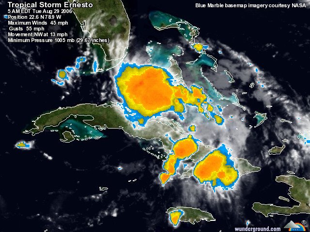
Ernesto RadarAh, summer. A time for fishing, swimming, boating, beaching and watching enormous radar blobs approach the state of Florida. If you've been following the storm, you'll see the track has changed since Sunday (I couldn't write yesterday due to a small household accident that confined me to the couch) and that its prolonged journey over Cuba weakened it from a hurricane to a tropical storm. Now that it's back over water, it will restrengthen, but hopefully not much, before it makes landfall.
Ernesto Forecast Track
Ernesto is now forecast to smack into our neighbors in the Keys and run up the middle of the state before going back out to sea. A second US landfall somewhere in the neighborhood of the Carolinas is also forecast by the National Hurricane Center. Check out the satellite views of Ernesto to watch the center begin to form again.

Ernesto killed two people in Haiti before striking Cuba where it reportedly dropped some seven inches of rain. South Floridians still trying to recover from the 2005 season are being told to evacuate their FEMA trailers before the storm hits. The wisdom is undeniable: a trailer can't withstand the impact of even a strong tropical storm, but the irony and misery of the situation are also undeniable. The storm also forced NASA to cancel the space shuttle Atlantis launch.

And, if you can't take any more bad news, here's something from the humor files: FEMA claims it's ready for Ernesto. If that doesn't make you laugh, you haven't been paying attention.

Depending on the strength at landfall, we could get some tropical storm force winds here, so we'll be packing up the patio projectiles today. We have plenty of everything and we're as ready as possible...

Sunday, August 27, 2006

Good Morning, Hurricane Ernesto

Hurricane Ernesto We woke up to a new track this morning, which is not surprising this far out from landfall. Ernesto is now a hurricane and predicted to come right into our front yard. The computer models from Weather Underground show the possiblities, including a panhandle or more northerly landfall. The NHC discussion seems to indicate confidence in a west coast strike. However, it's still early and, as we learned with Hurricane Charley in 2004, anything can happen. Hurricane intensity and tracks are difficult to predict especially when they're young storms like this one.

However, given that most of the computer models agree that Ernesto will make an easterly turn once it gets into our neighborhood, we'll start boarding up the Hunker Bunker on Tuesday/Wednesday. Unless there are some drastic changes in the forecast, we'll probably have to evacuate, so all you low lying folks who count on the Bunker: let's make a plan.

Here we go, kiddies. Never a dull moment in Hurricane Land.

Saturday, August 26, 2006

Tropical Storm Ernesto to Visit the Gulf

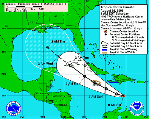
ErnestoTropical Storm Ernesto looks as if it will make a visit to the Gulf of Mexico. The models seem to predict a North Central Gulf Coast hit. It's still too early to tell, but here's the lastest discussion from the National Hurricane Center:
AN AIR FORCE PLANE HAS BEEN INVESTIGATING ERNESTO AND FOUND THAT THE CENTRAL PRESSURE DROPPED TO 999 MB WITH A WELL-ESTABLISHED CYCLONIC CIRCULATION. HOWEVER FLIGHT LEVEL WINDS HAVE NOT INCREASED MUCH SINCE THE PREVIOUS FLIGHT. IT APPEARS THAT THE CENTER IS LOCATED ON THE WESTERN PORTION OF THE LARGE DEEP CONVECTIVE MASS DUE TO THE CURRENT SOUTHWESTERLY WIND SHEAR. ALTHOUGH DVORAK INTENSITY ESTIMATES SUPPORT 45 KNOTS...THE INITIAL INTENSITY IS KEPT AT 40 KNOTS BASED ON AVAILABLE REPORTS FROM THE AIRCRAFT. ERNESTO HAS BEEN A FIGHTER AND HAS BEEN ABLE TO SURVIVE THE STRONG SHEAR SO FAR. UNANIMOUSLY...ALL GLOBAL MODELS DEVELOP AN UPPER-LEVEL RIDGE OVER ERNESTO...A PATTERN WHICH IS CONDUCIVE FOR STRENGTHENING. THIS UPPER-LEVEL PATTERN COMBINED WITH THE VERY WARM WATERS AHEAD OF THE CYCLONE COULD LEAD TO SIGNIFICANT STRENGTHENING OVER THE NEXT FEW DAYS. THIS COULD RESULT IN ERNESTO BECOMING A POWERFUL HURRICANE IN THE GULF OF MEXICO. THE INTENSITY FORECAST IS LOWER THAN THE GFDL AND VERY SIMILAR TO SHIPS AND FSU SUPERENSEMBLE. OF COURSE...THE INTENSITY FORECAST IS HIGHLY UNCERTAIN AND STRENGTHENING MAY NOT OCCUR AT ALL IF THE SHEAR DOES NOT DECREASE.

IN SUMMARY...ERNESTO COULD BECOME A POTENTIALLY DANGEROUS HURRICANE AS IT MOVES ACROSS THE NORTHWESTERN CARIBBEAN SEA AND THE GULF OF MEXICO. INTERESTS IN THESE AREAS SHOULD CLOSELY MONITOR THE PROGRESS OF THIS SYSTEM.
We'll be monitoring. Believe me.

Wednesday, August 23, 2006

Tropical Storm DebbyTropical Storm Debby appears to shaping up as a good fish storm and nothing more. The National Hurricane Center discussion indicates that Debby might yet strengthen into a hurricane, but the models predict that she will avoid land and make a hard right out to sea.

More as the activity off the Cape heats up. It's that time of year...