 Courtesy NOAA
2005 Forecast Forecast Activity as of: 12/03/04 04/01/05 Named Storms (NS) (9.6) 11 13 Named Storm Days (NSD) (49.1) 55 65 Hurricanes (H)(5.9) 6 7 Hurricane Days (HD)(24.5) 25 35 Intense Hurricanes (IH) (2.3) 3 3 Intense Hurricane Days (IHD)(5.0) 6 7 Net Tropical Cyclone Activity (NTC)(100%) 115 135 Check the right sidebar for a 2004 comparison and link to last year's scoreboard. Probabilities For At Least One Major (Category 3-4-5) Hurricane Landfall On Each Of The Following Coastal Areas:
Regional Probability Forecast:
1) Entire U.S. coastline - 69% (average for last century is 52%)
2) U.S. East Coast Including Peninsula Florida - 49% (average for last century is 31%)
3) Gulf Coast from the Florida Panhandle westward to Brownsville - 39% (average for last century is 30%)
4) Above-average major hurricane landfall risk in the Caribbean
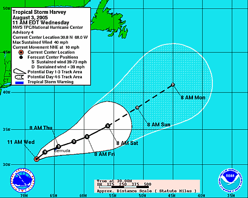 Meanwhile, Tropical Storm Harvey has arrived. As of a mid-afternoon advisory, Harvey is much stronger than originally believed.
An Air Force Reserve Unit reconnaissance aircraft sent to investigate Harvey reports that winds are at 60 mph, a mere 14 mph from hurricane strength. Harvey looks like it will torture Bermuda and then head out to sea to cause havoc in the shipping channels.
And out of the "Train Train Train" of activity coming off of Cape Verde, which I posted about yesterday comes a new tropical wave. From the NHC:
AN AREA OF LOW PRESSURE LOCATED A FEW HUNDRED MILES SOUTHWEST OF THE CAPE VERDE ISLANDS IS ASSOCIATED WITH A WESTWARD-MOVING TROPICAL WAVE. SOME SLOW DEVELOPMENT OF THIS SYSTEM IS POSSIBLE OVER THE NEXT COUPLE OF DAYS.If the wave develops into a tropical depression, it will be #9. (Oh, great! Now I'm going to have that stupid Yoko Ono song in my head all night.) If the depression develops into a storm, it will be named Irene.


1 comment:
btw,
The August 2005 issue of National Geographic has a nice article on hurricane trends. Apparently there is a relationship between ocean surface temp and hurricane frequency.
And, ocean surface temp has been above average since 1995...Nice colored graphics, too
cliffman
Post a Comment