Wednesday, July 13, 2005

Outside the Cone

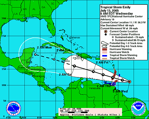
Florida is outside the cone for a change. Outside the cone is a lovely place to be. It gives us additional time to prepare for the next storm. We are getting an estimate on a hurricane door for our garage. I didn't much like the way the old door behaved when Dennis' winds came crashing up from the south, so we're looking at getting a "wind kit" or just upgrading the whole door.

The garage door, because it is such a large opening, is the Achilles heel for most homes. Once the wind enters your home, the roof comes off. Once the roof comes off...well, you're toast. Wet toast, but toast just the same. I will explore this more in the coming chapters of my book, which will be posted as hurricane activity allows me time to edit and proof them.

It looks like Emily might crash into the Yucatan, which is hard for us to watch as we have friends on that peninsula, too. Manuela, Jesus Yanet, Alfredo, Yurson and Estrella: we're thinking about you.

As of now, the winds are not strengthening and hurricane watches and warnings have been downgraded to tropical storm advisories for the southern windward islands. Emily is not expected to reach hurricane strength before clearing the islands tonight as predicted earlier.

Tuesday, July 12, 2005

Good Morning Emily


BULLETIN
TROPICAL STORM EMILY ADVISORY NUMBER 7
NWS TPC/NATIONAL HURRICANE CENTER MIAMI FL
11 AM AST TUE JUL 12 2005

...EMILY STRENGTHENING...HURRICANE WATCHES ISSUED IN THE WINDWARD ISLANDS...

AT 11 AM AST...1500Z...HURRICANE WATCHES HAVE BEEN ISSUED FOR BARBADOS...GRENADA...THE GRENADINES...ST. VINCENT...AND ST. LUCIA...BY THE APPROPRIATE GOVERNMENTS. A HURRICANE WATCH MEANS THAT HURRICANE CONDITIONS ARE POSSIBLE WITHIN THE WATCH AREA WITHIN 36 HOURS.

AT 11 AM AST...THE GOVERNMENT OF TRINIDAD HAS ISSUED A TROPICAL STORM WATCH FOR THE ISLAND OF TOBAGO. A TROPICAL STORM WATCH MEANS THAT TROPICAL STORM CONDITIONS ARE POSSIBLE WITHIN THE WATCH AREA WITHIN 36 HOURS.

INTERESTS ELSEWHERE IN THE EASTERN CARIBBEAN SHOULD MONITOR THE PROGRESS OF EMILY.
Sigh...

Monday, July 11, 2005

Tropical Depression # 5

TD 5 PathTropical depression #5 has formed out of a tropical wave off of Cape Verde. It is forecast to become a tropical storm within the next 24 hours (by early morning on July 12). Its name will be Emily. It's too early to tell where it's headed.

Meanwhile, Gulf Coast residents are recovering from a direct hit from Dennis. Though it was still a hurricane when it made landfall, it had weakened to a category three and moved through the area quickly.
Damage Reports

There's a reason there are so many mobile homes in Florida (besides the large number of retiree-owned second homes). The state, supported by the elitist, bought-and-paid-for legislature and our illustrious anti-worker governor, is fundamentally opposed to paying a living wage. If you can't afford to rent a house, apartment or one of the ugly Florida condos that seem to multiply like maggots even as we sleep, your choices are pretty much living in your car or in a mobile home. (The choices are similar if you think about it. The mobile home is more spacious, but you can't pack up and drive it to Georgia when a hurricane threatens.) When a storm comes, those who need protection most are often lack the resources to even run and hide, let alone rebuild: Low -income Residents Hit Hard. If there is anything you can do to help someone in your immediate area...

The damage wasn't as bad as most had feared...
Dennis leaves modest damage in weary Florida

Though the storm has been over for less than 24 hours, the clean-up has already begun: Clean up Begins

And in the wake of the storm, the Florida panhandle looks again like paradise: A Perfect Monday Morning

As for our next storm, the NHC says:
"While there is presently some easterly shear with this system... as well as marginal thermodynamics ...the environment is expected to become more favorable for development in both regards over the next few days. Given this...slow but steady strengthening is anticipated over the next 72 hours...and the official forecast is in good agreement with ships and GFDL guidance. The GFDL...which develops the depression only slowly at first...continues to make the cyclone a significant hurricane in the Caribbean." --FORECASTER FRANKLIN
For an up-to-date "spaghetti model" view: Weather Underground.
For an explanation of the models: National Hurricane Center (NOAA)

Spaghetti Models
From this morning's NHC discussion of TD #5:
"The official forecast ... which is a little south of the previous forecast...is a blend of the GFDL and NOGAPS models. It is perhaps of interest to note that the NOGAPS ... which had only a so-so year last year ... is currently the best performing Atlantic track model so far in 2005 ... and the FSU Superensemble...which won hands down last year ... is struggling a bit." --FORECASTER FRANKLIN
NOGAPS is represented above in blue and GFDL is represented in red. The storm is currently about 1200 miles east of the windward islands with maximum sustained winds of 35 mph.

Sunday, July 10, 2005

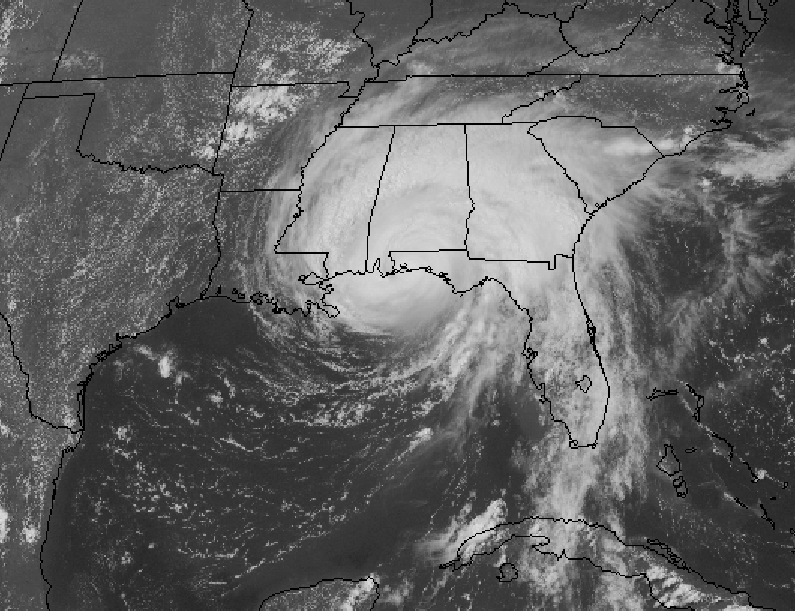
Dennis Makes Landfall In Florida

Dennis Makes Landfall
Hurricane Dennis has made landfall on Santa Rosa Island between Navarre Beach and Pensacola Beach, Florida. The local news reported sustained winds of 120 mph, which means Dennis was a category three 'cane as it came ashore. Our thoughts and hopes are with the people in Dennis' path right now. More info...

On the peninsula, the worst is over. It's hot again. The sun peeks out every now and then. The wind still howls faintly, but the storm has mostly passed.

For news on how the Tampa Bay area fared Bay News 9 has some decent coverage.

Feel compelled to help? Try the Red Cross National Disaster Relief Fund. It's tax deductible.

But wait, there's more...


TROPICAL WEATHER OUTLOOK
NWS TPC/NATIONAL HURRICANE CENTER MIAMI FL
1130 AM EDT SUN JUL 10 2005

FOR THE NORTH ATLANTIC...CARIBBEAN SEA AND THE GULF OF MEXICO...

THE TROPICAL WAVE LOCATED ABOUT 1250 MILES EAST OF THE LESSER ANTILLES CONTINUES TO SHOW SIGNS OF ORGANIZATION....AND THIS SYSTEM HAS THE POTENTIAL TO DEVELOP INTO A TROPICAL DEPRESSION DURING THE NEXT DAY OR TWO AS IT MOVES WESTWARD AT 10 TO 15 MPH.
Hang on. We're in for a wild summer.

Hurricane Dennis Drenches Gulf Coast

Dennis is now a category four hurricane. Our hearts and minds are with our fellow hurricane-weary souls on the northern Gulf Coast, where the impact of Dennis will be catastrophic -- at best. The forecast track takes it right to the folks who suffered through Ivan last year. I can't imagine the horror of watching Dennis approach now. All I can say is that the peninsula feels for you; we're watching and praying.

The storm is a couple hundred miles out to sea, yet it managed to deliver some nasty weather, including tornadic activity and flooding to the Sun Coast. We woke up to howling wind and pounding rain at about 5:00 this morning. As the outer bands pass through, we get small tornadoes, waterspouts and some microburst activity throughout the area. We opened the hunker bunker yesterday, but it wasn't necessary. It was really just an excuse to party and eat Chef James' cooking.

Flooding is a major concern on the barrier islands and near the intracoastal waterways. The picture at right shows this morning's high tide in Cortez. Sarasota Bay has pretty much taken over our friend's yard. Good thing he's the Captain; he's going to need a boat to get out of there today.

Our friend who lives on Anna Maria Island just called and said the beach where we always frolic is gone. "The water is right up to the steps of the houses and some of the rocks [that form a retaining wall there] are just gone," he said.

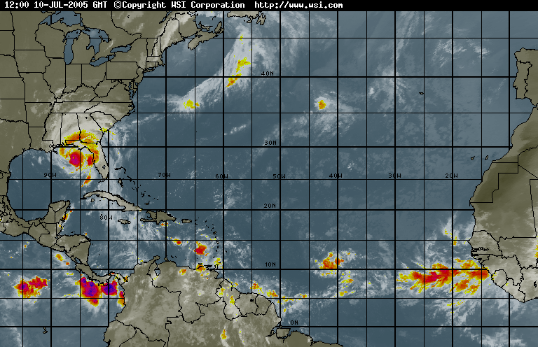
He's worried about the next storm...all of us are worried. This radar image from intellicast.com shows the energy just streaming off of the coast of Africa and strong thunderstorms building once again near the Caribbean Sea. The question isn't if we will have another hurricane, but when.

Though it's been a bad tropical storm, Manatee County has had very minimal damage and flooding. We were lucky. Again. But after last year's season, no one seems quite ready to breathe a sigh of relief. Maybe in November.

Saturday, July 09, 2005

Hurricane Dennis Update

Courtesy NOAA
Dennis RGB Dennis is brushing past the Florida Keys and pounding Key West with sustained tropical storm force winds and gusts nearing 70 mph. Power is out all over Key West and damage reports are coming in already. Many people there are still rebuilding from last year as are the people who are now preparing for a direct hit on the northern Gulf coast. Landfall is projected between the western Florida panhandle and the short stretch of Alabama coastline, both of which got slammed last year by Ivan.

As Dennis passed over Cuba, it weakened from a category four to a category one hurricane. Now that it has emerged into the Gulf of Mexico, it is beginning to restrengthen and is now a category two. It's expected to continue gaining strength over the warm Gulf, which is a hurricane-feeding 90 degrees right now.

We had some intense squalls last night as the outer band of Dennis passed over us and a repeat performance this morning when another band passed through. We're on the dangerous side of the storm, so depending on how far east Dennis tracks, we could see some tornadic activity and perhaps even some microbursts. We're hoping Dennis continues its westerly motion as it makes its way north, which will keep it a few hundred miles offshore. We'll still see high water and Anna Maria Island will likely see some flooding. Inland areas still suffering from heavy rainfall and rivers above flood stage will be the hardest hit.

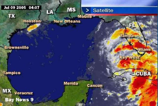
We're in for more squalls and bad weatherTampa Local Radar overall, to be sure. The lightning has been very intense, but the winds haven't been too bad yet. The radar picture at right (courtesy baynews9.com) shows the intense activity as the bands pass over the Florida peninsula.

The only bonus here is that the storm might help clear out the red tide that has been plaguing us since February. Or, according to the Bradenton Herald, the storm could provide it with just enough fresh water to create additional nutrients. Read more from the Herald...

Red tide is a toxic algae bloom that the press and state officials downplay because they don't want to scare off the tourists. As if a beach reeking of dead fish wouldn't drive people away. Besides killing fish and marine mammals, red tide causes respiratory problems in land mammals, like humans. Neither the short nor the long term effects of exposure to red tide are understood, but the mainstream media will tell you that red tide is not dangerous. Of course you can still go swimming and fishing. Just don't swallow the water or eat any shellfish. And if you start to cough and sneeze and feel like you're choking to death, you should probably leave the beach. Um...duh.

Our own Mote Marine is trying to understand how red tide affects humans, but the data is incomplete and so far inconclusive. Okay, this isn't News from Red Tide Land, so I'll stop there.

More later as Dennis continues churning up the Gulf coast.

Friday, July 08, 2005

This Just in From Cuba

HURRICANE DENNIS TROPICAL CYCLONE UPDATE
NWS TPC/NATIONAL HURRICANE CENTER MIAMI FL
310 PM EDT FRI JUL 08 2005

Reports from the Cuban Meteorlogical Service and Civil Defense through HAM radio operators indicate a wind gust to 149 MPH occurred at Cienfuegos, Cuba around 1:30 PM EDT. More than 85 percent of the powerlines were down and extensive damage has occurred to the communications infastructure.

FORECASTER STEWART

Link

A Very Pretty Picture of Hurricane Dennis

From the NOAA Satellilte and Information Service: Operational Significant Event Imagery

Dennis: Category Four Menace

Courtesy NOAA
Sorry I missed posting yesterday (it's a long story and more about me than you want to know) as Dennis jogged west and then east again. All in all, an exciting day for the ol' Menace.

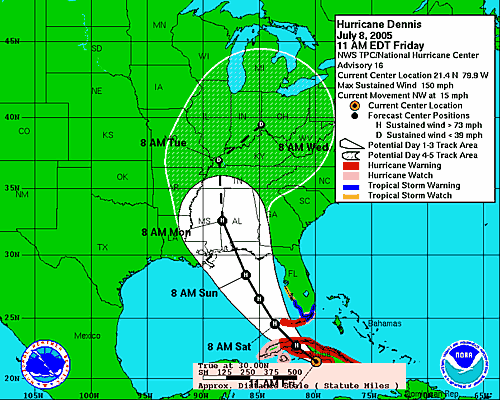
High pressure is holding over the Florida peninsula, so it appears at this time that Dennis is will skirt the west coast of the peninsula and make landfall on the north gulf coast somewhere between Louisiana and the Florida panhandle. Though we are currently outside the "cone" of uncertainty, this storm still bears watching as is has joggged east to west and back several times already.

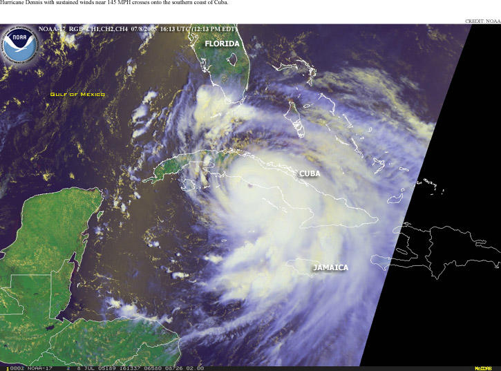
Dennis made landfall at Hispaniola yesterday and is currently pounding Cuba. A t least four people were killed in Haiti when a bridge collapsed and mud slides are said to have taken several lives in both Haiti and Jamaica, but the information coming out of the region is still spotty.

In this image, you can see Dennis's violent storms heading over Cuba. According to the Associated Press, Dennis packed 150 mph winds as it tore through Guantanamo, knocking down a guard tower at the U.S. terrorist prison camp there.

Evacuations have been ordered for the Florida Keys and tropical storm and flood warnings and watches have been posted for the southern Gulf coast of Florida. A tropical storm watch has been posted for our neighborhood as has a flood watch for both Saturday and Sunday. The local weather forecasters say we can expect high seas, high winds and lot of rain.

Though we aren't expecting a direct hit in the Tampa area, the track could change at any moment as we learned last year with Charley. The picture at left shows Dennis' east-west jogs over the last 36 hours. (Courtesy TBO.com.) The course changes are caused by weak areas in the edge of the high pressure system currently in place over the peninsula. Since the strength of the pressure area is not uniform (as it appears on television graphics), as Dennis skirts the high pressure ridge, stronger pressure areas push the storm west while weaker pressure areas allow it to shift eastward. It's probably still too early to tell how close Dennis will come to the Florida Gulf coast. A direct hit is unlikely at this time, but not completely impossible.

Whether Dennis makes a direct hit or not, we expect to have a fairly crappy weekend. I have to say: I cannot handle another "weekend hurricane season." Every hurricane that hit our area last year came through on a weekend, including Labor Day. I mean, we don't get "snow days" at work in Florida; we should get at least one or two "hurricane days."

We're not planning to shutter the house unless there is a dramatic shift in the projected track tonight, but we will open the Hunker Bunker this weekend for our friends on the island or nearer the Gulf who tend to lose power and/or water even in tropical storm force winds. (You know who you are. No need to call...just come on by.)

Wednesday, July 06, 2005

Cindy Hits Louisiana...Greedy Oil Men Hit all of Us

Correction to this post and thank those of you who pointed it out...I don't know what I was thinking...I know the Saffir-Simpson Scale by heart. Cindy came ashore at 70mph, 4mph short of hurricane strength...

Tropical Storm Cindy was near hurricane strength at 112 70 mph before making landfall near New Orleans. Hurricane strength is defined as sustained winds of 119 74 mph. I bet those Louisiana folks were counting their blessings that it wasn't a hurricane.

Cindy flooded streets, tore down power lines and twisted trees in the historic French Quarter district of the Mardi Gras city and left about a 1/4 million people without power throughout Louisiana. She dumped about ten inches of rain on the region on her trek inland.

Meanwhile, the headline in Forbes is: "Oil Prices Top $60 a Barrel on Storm Fears." While it's certain that drilling operations in the Gulf of Mexico were suspended and production might just suffer a little bit, let's get a grip folks. This was an itty-bitty storm. Itty-bitty-Teeny-weeny storm. If this is what we have to look forward to this season, we'll be at $5 per gallon at the pumps in no time. (Personally, I'd pay $10 a gallon if they'd stop drilling in our beautiful Gulf. But I'm pretty sure that's just me. Sigh.) Read the story...

Cindy is now just a tropical depression, a term that begins to take on many meanings in Florida at this time of year. But wait! There's more! We also get this fabulous Tropical-Storm-Soon-To-Be-Major-Hurricane named Dennis. At no extra charge!

All the forecast tracks so far say Dennis will hit the Florida Panhandle. But, funny (peculiar, not ha-ha) thing about hurricane tracks: hurricanes don't always follow them. Ask Port Charlotte. So, if you're in Florida, you're in the cone of uncertainty at this point and you can't afford to take it lightly. More on Dennis in the next post...

Tuesday, July 05, 2005

Named Storm #4: Dennis

Courtesy NOAA

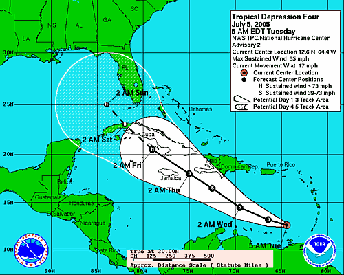
As predicted, TD #4 became Tropical Storm Dennis this morning. The five-day path shows Tampa Bay in the "cone of uncertainty," meaning it could strike here or not.

By all accounts, Dennis should be our first hurricane of the season.

Something tells me we'll be spending some quality time with plywood and tapcons this weekend. And so it begins...

Tropical Storm Cindy and Warming up for Dennis

Cindy and DennisCindy is about right in the middle of the Gulf of Mexico, projected to make landfall somewhere along the coast of Louisiana late tonight or tomorrow morning. At 7am CDT, the center was located near latitude 26.4 north...longitude 90.4 west and sustained winds were about 45mph.

The Florida peninsula is under high pressure, which keeps Cindy away from us, pushing her toward the North Central Gulf coast. A tropical storm watch is in effect from east of Pascagoula to Destin, Florida. Cindy is a poorly organized storm for the moment, but the NHC predicts it might strengthen somewhat before landfall.

Meanwhile, to our south, Tropical Depression #4 is strengthenging in the Caribbean. As of 5am EDT TD #4 was nearing tropical storm force as was located 670 KM South-Southeast of San Juan, Puerto Rico. TD #4 will most likely become Dennis before the end of the day.

I don't like the looks of the-storm-that-will-be-Dennis. It's forming it just about the same area that Ivan did in 2004 and it appears there will be plenty of time for strengthening as the NHC expects its forward speed to slow. It's forecast to enter the Gulf of Mexico this weekend and will be spinning just south of our latitude early Sunday morning.

Our hurricane kit and shutters are at the ready, but we'll take stock of both this week to ensure we're as prepared as one can possible be when the hounds of hell come calling. As always, check here for information as to whether we'll be evacuating or opening the hunker bunker.

Wednesday, June 29, 2005

Hellllloooooo Bret!

Tropical storm Bret arrived yesterday in the Bay of Campeche, which is pronounced "CAHm - pӘch-EH," not "Campeechy" as it is so mangled by our local newcasters.*

Bret began as a cluster of organized thunderstorms organized as Tropical Depression Two or TD #2 as those of us so enviably in the know would call it. At some point between 8 and 11 last night, it strengthened enough to become a tropical storm and hence got its name.

Bret made landfall near Tuxpan, México some time after 8:00 this morning and has now weakened to a rainmaker. It is, thankfully, dying out.

More info on Bret: National Hurricane Center.

Current counts are posted at right.

*Please pardon me for using "eh" in place of the "long a" symbol; I couldn't find a character entity to render it properly.

Monday, June 13, 2005

Arlene Pisses on Florida & Another Waiting in the Wings

Now we've been hit by our first tropical storm of the season. Doesn't it feel better to get that out of the way? Arlene came ashore near the Florida panhandle on Saturday, drenching the peninsula in rain on her way through.

Check out the image archives on the NHC site to see her final path. She's now a non-event. Just an inland rainmaker.

All we saw here was a strong south wind, which was actually quite nice because it gets blistering hot when the storms blow through. Arlene ruined the scheduled Poker Run (by boat) over the weekend, but that was the sum total of the destruction here.

There is another area of disturbance in the Caribbean now. Some disorganized thunderstorms the talking weather heads say we'll have to look out for. I don't know about anyone else, but this is a little early for me.

Friday, June 10, 2005

Birth and Insurance Rates on the Rise

Seems last year's hurricane season created a baby boom in Florida, which is now manifesting itself in maternity wards across the state. Some hospitals report an increase in deliveries of more than 20% for June.

As if it's not hot and sweaty enough without air conditioning, people inexplicably felt the need to get hotter and sweatier...apparently with each other. And without birth control. One woman I saw on the local news said, "We were bored." There's a story to tell the kid: "You were conceived out of boredom." Story...

In other news, insurance companies, fed up with actually having to pay claims after collecting millions of dollars of premiums, are planning to raise rates and/or cancel coverage for Florida homeowners. Feel the love, eh?


Cincinnati Indemnity Co.
wants 36.7% higher premiums from Floridians.

You're in Greedy Hands with Allstate. They didn't mind collecting premiums right up until June 1, but now, suddenly, Florida's just too risky for them.

Randy Schultz's opinion piece reveals Allstate's neat "sleight of hand" accounting tricks designed to fleece Florida homeowners.

And if you think Jeb is going to help, think again. He's part of the dynasty that is firmly sewed into the pocket linings of big business in America (and Saudi Arabia, but that's a topic for another blog.) Hold on to your hats, Florida. You're about to get screwed by Mother Nature, insurers and the state legislature. Next year's baby boom will be interesting...new moms interviewed from their new homes in the back seats of their cars.

Tropical Storm Arlene Edges East

Arlene's projected path has shifted a little eastward. Is it just me or does it seem a bit unfair and a bit of a bad omen that the first storm of the season is A) so early B) probably going to smack into Florida. I mean, really, didn't Florida get enough last year?


Courtesy NOAA/NHC

Here's a very pretty picture of Arlene. Pretty, that is, if you aren't still traumatized from last year's radar blob overdose.


Courtesy NOAA/NHC

Arlene is now poised to ruin our weekend with rain and clouds and wind. Don't these storms know that weekdays are the best time to hit? Jeez, you'd think they're working for our employers.

So, hello from HurricaneLand where it's deja vu all over again.

Thursday, June 09, 2005

Arlene Projected to Blow by Florida Panhandle

And so it begins. We have our first named storm. It started as TD #1 yesterday. I was just getting ready to blog on it when our power went out due to an everyday summer storm. Rather than sit and sweat inside a dark, quiet house, I went to the Cortez Kitchen with a friend and had a sandwich, leaving my husband and our friend the Captain behind to guard the house (the garage door was up and there was no electricity to power it down.) Seems I forgot about blogging and TD #1 after a couple of beers. Imagine that.

But this moring, there it was: Tropical Storm Arlene.
BULLETIN
TROPICAL STORM ARLENE SPECIAL ADVISORY NUMBER 4
NWS TPC/NATIONAL HURRICANE CENTER MIAMI FL
8 AM EDT THU JUN 09 2005

...SHIP REPORT INDICATES TROPICAL DEPRESSION ONE HAS BECOME TROPICAL STORM ARLENE...THE FIRST TROPICAL STORM OF THE 2005 SEASON...
As I write, it's just south of Cuba, projected to come into the Gulf of Mexico tomorrow and screw up our weekend weather. I don't know about anyone else, but I'm thinking that starting the season with a storm in the Gulf is not exactly a sign of good things to come. The water has only recently reached 88 degrees, so maybe there won't be enough energy in the Gulf to feed Arlene.

The forecast track (HaHaHaHaHaHaHaHa) takes Arlene just west of the Panhandle. If we learned anything last year we learned this: Don't focus on the line. Focus on the cone.

Image Courtessy NOAA/NHC

So, how's your hurricane kit looking?

Friday, June 03, 2005

Florida Hurricane Survival Guide For Newbies - Introduction


Florida Hurricane Survival Guide For Newbies

By Loretta Cochran

Introduction
How We Got Here from There

It seems everyone in Florida is from somewhere else, so I thought I'd begin by telling you how and why we moved 3200 miles to sit right smack dab in the center of Hurricane Land.

My husband and I moved to lovely Bradenton, Florida from Vancouver, Washington in May of 2002. Also known as “the other Vancouver,” our former haunt is a small suburb of Portland, Oregon, a mid-sized city much like Tampa, which lies just across the Columbia River. The area boasts an average of 32 clear days a year, which the tourist guidebooks will tell you is perfect weather for the Redwood Rainforest. It is also good weather for ducks—not the Ducks, but real ducks, which should not be confused with the University of Oregon’s football team as real ducks are much tougher and have nicer uniforms.

In that climate, water falls on one’s head for an average of 333 days per year, except at those magical times when the Arctic winds shift from northerly to northeasterly and come screaming out of the Columbia Gorge with the force of the Furies themselves. This effectively transforms otherwise miserably cold raindrops to freezing shards of glasslike water propelled at one’s face at a perpendicular angle by 40-mile per hour shrieking winds. Locally, this is called “freezing rain.” You can simply think of it as sleet on steroids; it pierces the skin with the efficiency of a disgruntled acupuncturist and makes you yearn for a gentler climes. Like Alaska.

During one such bout with what Northeasterners would call a “real” winter, the novelty thermometer on our patio read “pretty cold” then “really cold” then “freaking cold” and finally “how can you [expletive deleted] live here?” It was without a doubt the best question ever asked by an inanimate object. Jim and I were certainly stumped.

So, with grand plans to live as paupers in paradise, we left behind highways that resembled skating rinks, skies that never cleared and incomes in the upper tier of the upper middle class. We packed up our most valued possessions, our permafrost toes, perpetually runny noses and ran, seeking sun, sand, palm trees and subsistence wages in Sunny Florida. We were not disappointed on any of the above, particularly the latter. It seemed as if our strategy was playing out beautifully. For the first two summers, life seemed idyllic despite our depression that the going wages in our fields of work were one-third to one-half of what they were out west. The quality of our lives had improved so much that it scarcely mattered. Every weekend seemed like a vacation, so who needed money? Who needed to get away from it all? Get away from what? White sand beaches? Dreamy turquoise water? A close-knit community unlike any we’d ever known and into which we were almost immediately accepted?

We swam in the ocean nearly every day. On our first 4th of July, we encountered a manatee in the warm Gulf waters. I learned to snorkel. Jim caught a black tip shark on his first fishing trip. I fished in saltwater for the first time. My first catch was a toadfish. I don't know if you've ever seen one, but it is one of the absolutely ugliest creatures on the planet and when I pulled it out of the water I screamed like I'd pulled up the devil itself, which by all logic it seemed that I had. But I still loved my new home.

We watched the “Tropical Updates” on the local news station with only casual interest. After all, the Northwest was famous for its erupting volcanoes, sudden and violent earthquakes, mudslides and ice storms that shut down power grids and entire cities for days on end. We’d both breezed through several six-plus magnitude earthquakes. I had personally witnessed the second large eruption of Mt. St. Helens from a distance of less than forty miles and somehow lived through the ash fallout. We were coming from an extremely harsh climate and were no strangers to natural disasters; we were foolishly brave. That is, until 2004 when it seemed every hurricane had its eye on Florida.

It wasn’t as if we were unaware of the danger of hurricanes when we chose Florida. Who could forget the widely reported devastation of Andrew? We didn’t live in a cave, contrary to some East Coast perceptions of Pacific Northwesterners, a perception that envisions us as raised-by-wolves, animal skin-clad hunters and gatherers with highly developed canine teeth perfect for ripping flesh from the bones of our kill. Though it is at times helpful to perpetuate this stereotype, for example, when arriving in the checkout line at the Winn-Dixie, it’s not even remotely accurate. We had cable TV and indoor plumbing and everything. We were as versed as any American in national and world events. (Okay, that’s not saying much. I’ll give you that.)

The horrific things we didn’t know about when we moved to Florida include astonishingly prolific lightning storms, palmetto bugs (roaches, just bigger and crunchier when you step on them), the voracious appetites of unseen noseeums, mosquitoes the size of SUVs, poisonous snakes, fire ants, red tide, filthy Florida politics and the fact that no-name storms can be as lethal as quaintly monikered hurricanes. But those surprises are topics for my next books: Florida Outdoor Survival Guide for Newbies: Fun With Deet and Florida Political Survival Guide for Newbies: Come On…You Didn’t Really Think Your Vote Would Be Counted.

But I digress.

We moved here with the intent to live and work here, and to become as much a part of our community as we were in Vancouver, which is to say we expected to carry with us the tradition of a morning nod in the direction of our neighbors whose names we didn’t know and at whose noisy children we routinely directed mumbled curses. Little did we know that we’d settle in a community just outside Florida’s last remaining fishing village and form profound bonds with people we’d known for mere months—even before the dastardly hurricane season of 2004 when it seemed at times that we all needed each other more than we needed oxygen.

A hurricane bearing down on your neighborhood schools you in both the value of and your responsibility to your community in an instant. And that’s what the first hurricane of the season, Charley, did for us when we turned on the Tropical Update and saw that line up the center of the "cone of probability" (kind of like the cone of silence, but less effective.) That line was overlaid right on top of our precious newfound community. That scary black line in the center of the cone passed right through our neighborhood. Right through our house. Right through everything that had made us so very happy for the previous two years. And we had no idea what we were supposed to do.

Next up: Chapter One: Two Rules
Wednesday, June 01, 2005

First Day of Hurricane Season

Today is the first day of hurricane season and for the occasion, the venerable Dr. William M. Gray et al. at the Tropical Meteorology Project have revised the forecast upward. If you listen closely you can hear the sound of an entire state letting out a heavy sigh of resignation...tinged with worry...tinged with terror.

If you are warmed by numbers, you will be happy to learn that statistically speaking, it is highly unlikely that Florida will be hammered by 170 hurricanes again this year. But before you become too complacent, remember this: after every hurricane last year, someone invariably said "statistically speaking, it's highly unlikely we'll get hit again." And yet a major hurricane made landfall in Florida roughly every ten days between mid-July and the end of August. I feel fully justified for hating my college statistics class.

Dr. Gray's new forecast:
2005 Forecast
Forecast Activity as of: 04/01/0505/31/05
Named Storms (NS)
13
15
Named Storm Days (NSD)
65
75
Hurricanes (H) 7
8
Hurricane Days (HD) 35
45
Intense Hurricanes (IH) 3
4
Intense Hurricane Days (IHD) 7
11
Net Tropical Cyclone Activity (NTC) 135 170
Check the right sidebar for a 2004 comparison and link to last year's scoreboard.
Dr. Gray and his team do not expect El Nino conditions to develop this summer. They also predict an above-average probability of US landfalls this season. Oh joy.
Regional Probability Forecast:

Probabilities For At Least One Major (Category 3-4-5) Hurricane Landfall On Each Of The Following Coastal Areas:
1) Entire U.S. coastline - 77% (average for last century is 52%)
2) U.S. East Coast Including the Florida Peninsula - 59% (average for last century is 31%)
3) Gulf Coast from the Florida Panhandle westward to Brownsville - 44% (average for last century is 30%)
4) Expected above-average major hurricane landfall risk in the Caribbean and in the Bahamas
In my last post, I promised you excerpts from my new book, Florida Hurricane Survival Guide for Newbies. I have not forgotten. I decided to wait until the beginning of season, which is now (sigh) here. I'll post the introductory chapter within 24 hours.

Tuesday, April 05, 2005

2005 Hurricane Season Forecast

Only 76 Days Until Hurricane Season Begins - Do you know where your flashlight batteries are?

As the 2005 hurricane season approaches, The Tropical Meteorology Project team predicts another wild season for the Atlantic: "We foresee a slightly above-average hurricane season for the Atlantic basin in 2005. Also, an above-average probability of U.S. major hurricane landfall is anticipated. We do not, however, expect anything close to the U.S. landfalling hurricane activity of 2004."

You may think that's good news. The problem is, hurricanes rarely take their marching orders from meteorologists. Here are the forecasts issued on December 4, 2004 and a subseqent forecast issued April 1, 2005 (presumably not an April Fool's joke:
2005 Forecast
Forecast Activity as of: 12/03/0404/01/05
Named Storms (NS) (9.6) 11 13
Named Storm Days (NSD) (49.1) 55 65
Hurricanes (H)(5.9) 6 7
Hurricane Days (HD)(24.5) 25 35
Intense Hurricanes (IH) (2.3) 3 3
Intense Hurricane Days (IHD)(5.0) 6 7
Net Tropical Cyclone Activity (NTC)(100%) 115 135
Check the right sidebar for a 2004 comparison and link to last year's scoreboard.
If you haven't started preparing yet, it's time to start thinking about it.
Regional Probability Forecast:

Probabilities For At Least One Major (Category 3-4-5) Hurricane Landfall On Each Of The Following Coastal Areas:
1) Entire U.S. coastline - 69% (average for last century is 52%)
2) U.S. East Coast Including Peninsula Florida - 49% (average for last century is 31%)
3) Gulf Coast from the Florida Panhandle westward to Brownsville - 39% (average for last century is 30%)
4) Above-average major hurricane landfall risk in the Caribbean
In the coming days and weeks, I will be posting excerpts from my new book, Florida Hurricane Survival Guide for Newbies. The material is drawn directly from my first encounter with hurricanes in the maddening season of 2004. If you're new to Florida, I hope the lessons I learned last year will help you through your first hurricane season.