 From the National Hurricane Center:
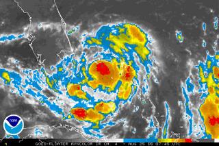
 A HURRICANE WARNING REMAINS IN EFFECT FOR THE SOUTHEAST FLORIDA COAST FROM VERO BEACH SOUTHWARD TO FLORIDA CITY...INCLUDING LAKE OKEECHOBEE. A HURRICANE WARNING MEANS THAT HURRICANE CONDITIONS ARE EXPECTED WITHIN THE WARNING AREA WITHIN THE NEXT 24 HOURS. PREPARATIONS TO PROTECT LIFE AND PROPERTY SHOULD BE RUSHED TO COMPLETION.Katrina is now about 90 miles east of Ft. Lauderdale and moving slowly toward the Florida peninsula. Bryan, you take care of yourself out there in FTL! Text me and let me know how it's going.
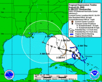
The NHC has revised yesterday's forecast and now warns that Katrina will likely become a category one hurricane before it makes landfall. Yesterday they had predicted that Katrina would be a tropical storm at first landfall on the peninsula and then strengthen to a hurricane over the warm Gulf water (93 degrees!!!) before it hits Florida again somewhere along the panhandle.

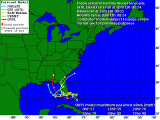
The computer models shown in this image [courtesy of Weather Underground] are in pretty good agreement about the first landfall, but once Katrina gets out over the Gulf of Mexico, it's hard to say where it will go. There's little doubt that it will become a hurricane again before second landfall, so everyone in the cone should be preparing for the worst while hoping for the best.
To our subscribers and friends in the Panhandle: we're all hoping Katrina turns in any direction but yours. Here on the Sun Coast, we're agreed that you've been through quite enough in the last 12 months. If the storm does hit there, hopefully, Phil will be in touch with Hurricane Land to let us know what's going on.
We'll be watching the storm all weekend. It's not like there will be anything else to do! Stay tuned. We're just getting warmed up in Hurricane Land.


No comments:
Post a Comment