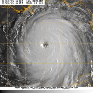
 If Katrina's eye makes a direct hit or passes just west of the city, words like "catastrophic" and "devastating" will not begin to describe the damage. New Orleans lies below sea level and the city relies on a delicately balanced system of levees and pumps to keep water from engulfing the city. With a category five, the storm will send a twenty foot (or more) wall of water rushing into city. The levees designed to keep the sea out, will hold the storm surge in. Ironic, isn't it? Even if the power stays on, which is highly unlikely, the city's pump system cannot handle the volume of water that will accompany a category five or even a category four storm. See Eric Berger's Sci Guy Blog for an in-depth discussion of the potential Waterloo New Orleans is now preparing to meet.
Residents are streaming out of the city now. Many elderly residents have lived in New Orleans all their lives and have never owned or even drove a car. (You don't need a car in New Orleans. It's beautifully designed for walking and public transport.) Officials say they are trying to get to these people, but...well...figure it out...they simply can't get to everyone.
Wherever Katrina comes ashore, it's not going to be pretty. This is one hell of a huge storm. It scares me to look at it - even knowing it's not going to come ashore here. Let's just hope and pray that Katrina decides to pass a bit east of the Big Easy. Our thoughts are with everyone - on land and sea - in Katrina's path.


No comments:
Post a Comment