 http://www.nhc.noaa.gov/satellite.shtml
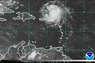
Tropical Storm Chris is getting its act together. While I don't think this will affect the west gulf coast, any storm in the area bears watching. Besides, it's a good reminder to check your supplies. We replaced the batteries in our weather radio today. ..something we should have done weeks ago when Alberto breezed through.
The computer models have yet to converge and the discussion over at the National Hurricane Center goes like this:
WTNT43 KNHC 021447TCDAT3Even though we're in the five-day cone there's no need to worry about Chris at the moment, but it's always best to be prepared. Personally, I'm not all that fond of fighting my friends and neighbors for basic supplies while a storm howls out in the Gulf. That's why I've been looking at over a dozen gallons of purified water sitting here on the floor of my home office since before June first.
TROPICAL STORM CHRIS DISCUSSION NUMBER 8
NWS TPC/NATIONAL HURRICANE CENTER MIAMI FL AL032006
1100 AM EDT WED AUG 02 2006
Data from the San Juan WSR-88D Doppler radar and high-resolution visible satellite imagery suggest that Chris is gradually becoming better organized as it continues toward the west-northwest near 9 KT. Initial intensity is set at 55 kt in accordance with the last recon-measured flight-level winds of 67 kt and DVORAK T-numbers of 3.5 from both TAFB and SAB. Cirrus motions indicate that Chris continues to be experiencing some northerly shear. On the predicted track...and based on the 200 MB wind forecast from the GFS...Chris will be in a COL region between two upper-level cyclones during the next few days. This is a reasonably favorable upper-level environment...so a gradual increase in strength is forecast. The NHC wind speed forecast is similar to the latest ships guidance and a little above the FSU Superensemble prediction. As always...it should be recalled that tropical cyclone intensity forecasts at 3-5 days have little skill.
Latest center fixes suggest little change in the initial heading or speed. Global models indicate that the mid/upper-level low near the Central Bahamas will move westward and slowly weaken over the next few days...while a rather strong mid-tropospheric ridge builds to the north of Chris. This kind of flow pattern would steer the tropical cyclone on a general west-northwestward track. However an even stronger ridge would likely drive Chris westward. Indeed...this is the scenario offered by the GFDL model which even turns the system west-southwestward for a while. Whereas the GFDL is a highly credible model...the most prudent course at this time is to use the consensus of all of the dynamical models. This is also very similar to the previous NHC track. [Emphasis mine]
If you live in Florida, think of Chris as your second wake-up call. If you hit the snooze button after Alberto, it might be wise to put your feet on the floor this time and start getting ready to survive up to a month without power or water.
The height of hurricane season is coming. And FEMA isn't.


No comments:
Post a Comment