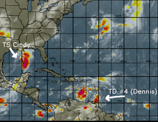
 Cindy is about right in the middle of the Gulf of Mexico, projected to make landfall somewhere along the coast of Louisiana late tonight or tomorrow morning. At 7am CDT, the center was located near latitude 26.4 north...longitude 90.4 west and sustained winds were about 45mph.
The Florida peninsula is under high pressure, which keeps Cindy away from us, pushing her toward the North Central Gulf coast. A tropical storm watch is in effect from east of Pascagoula to Destin, Florida. Cindy is a poorly organized storm for the moment, but the NHC predicts it might strengthen somewhat before landfall.
Meanwhile, to our south, Tropical Depression #4 is strengthenging in the Caribbean. As of 5am EDT TD #4 was nearing tropical storm force as was located 670 KM South-Southeast of San Juan, Puerto Rico. TD #4 will most likely become Dennis before the end of the day.
I don't like the looks of the-storm-that-will-be-Dennis. It's forming it just about the same area that Ivan did in 2004 and it appears there will be plenty of time for strengthening as the NHC expects its forward speed to slow. It's forecast to enter the Gulf of Mexico this weekend and will be spinning just south of our latitude early Sunday morning.
Our hurricane kit and shutters are at the ready, but we'll take stock of both this week to ensure we're as prepared as one can possible be when the hounds of hell come calling. As always, check here for information as to whether we'll be evacuating or opening the hunker bunker.


No comments:
Post a Comment