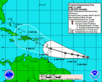
 Tropical depression #5 has formed out of a tropical wave off of Cape Verde. It is forecast to become a tropical storm within the next 24 hours (by early morning on July 12). Its name will be Emily. It's too early to tell where it's headed.
Meanwhile, Gulf Coast residents are recovering from a direct hit from Dennis. Though it was still a hurricane when it made landfall, it had weakened to a category three and moved through the area quickly.
Damage Reports
There's a reason there are so many mobile homes in Florida (besides the large number of retiree-owned second homes). The state, supported by the elitist, bought-and-paid-for legislature and our illustrious anti-worker governor, is fundamentally opposed to paying a living wage. If you can't afford to rent a house, apartment or one of the ugly Florida condos that seem to multiply like maggots even as we sleep, your choices are pretty much living in your car or in a mobile home. (The choices are similar if you think about it. The mobile home is more spacious, but you can't pack up and drive it to Georgia when a hurricane threatens.) When a storm comes, those who need protection most are often lack the resources to even run and hide, let alone rebuild: Low -income Residents Hit Hard. If there is anything you can do to help someone in your immediate area...
The damage wasn't as bad as most had feared...
Dennis leaves modest damage in weary Florida
Though the storm has been over for less than 24 hours, the clean-up has already begun: Clean up Begins
And in the wake of the storm, the Florida panhandle looks again like paradise: A Perfect Monday Morning
As for our next storm, the NHC says:
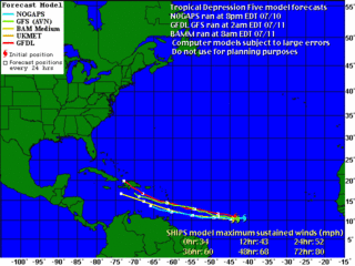
"While there is presently some easterly shear with this system... as well as marginal thermodynamics ...the environment is expected to become more favorable for development in both regards over the next few days. Given this...slow but steady strengthening is anticipated over the next 72 hours...and the official forecast is in good agreement with ships and GFDL guidance. The GFDL...which develops the depression only slowly at first...continues to make the cyclone a significant hurricane in the Caribbean." --FORECASTER FRANKLINFor an up-to-date "spaghetti model" view: Weather Underground.
For an explanation of the models: National Hurricane Center (NOAA)

From this morning's NHC discussion of TD #5:
"The official forecast ... which is a little south of the previous forecast...is a blend of the GFDL and NOGAPS models. It is perhaps of interest to note that the NOGAPS ... which had only a so-so year last year ... is currently the best performing Atlantic track model so far in 2005 ... and the FSU Superensemble...which won hands down last year ... is struggling a bit." --FORECASTER FRANKLINNOGAPS is represented above in blue and GFDL is represented in red. The storm is currently about 1200 miles east of the windward islands with maximum sustained winds of 35 mph.


No comments:
Post a Comment